Stage: Planning phase · Independent project
Sources
Every fact on this site comes from our feasibility brief. The brief lists the public sources behind its facts and marks our own estimates and assumptions. Here are all 203 sources, each with a label that says how sure we are.
Brief version 1.3 · Sources accessed October 18, 2026
A plain-text file. It may download, and any text editor can open it.
How sure are we?
We did all of this research online: two rounds, then a focused update for version 1.1. Each source below carries one of four labels.
Fact-checked47 of 203 sources
These sources come from round 2, when an independent fact-checker tried to prove each claim wrong. Facts it confirmed or corrected count as checked. Facts from an official page that it could not re-check are marked Single source.
Search extract74 of 203 sources
These sources come from round 1. We read the short extract of each page that a search engine showed, because the full page could not be opened.
v1.1 search extract77 of 203 sources
These sources were added in the October 2026 update (version 1.1): county records on Gall Farm Preserve, plus searches on electricity service, bus and trail access, and missing source links. We again read search extracts. In this update, a fact counts as checked when two or more independent or official sources agree.
To verify against official text5 of 203 sources
These are national rules, standards and safety guides, such as the ADA 2010 Standards and the FDA Food Code. We have not yet checked them against their full official wording.
How the research rounds worked
- Round 1 covered six topics: city sites, regional sites, nearby attractions and examples elsewhere, rules, funding and costs, and transit and plans.
- Round 2 added eight more research streams to fill the gaps.
- Of the round-2 claims, 65 were confirmed and 14 were corrected. None was proven wrong. Another 86 could not be checked before the search limit ran out.
- In round 2, we left out claims from unofficial sources that could not be checked.
- Version 1.1 (the same day) added the owner’s correction about Gall Farm Preserve from county records, plus three focused searches: electricity service, bus and trail access for each area, and missing source links. They used about 70 more web searches.
What we could not do
- Network rules blocked full documents, so we read only search results and their short extracts.
- We could not open county parcel maps, FEMA flood maps, or city and township websites. FEMA is the federal agency that maps flood zones.
- The first two rounds shared one limit of 200 searches. We reached it, so some topics are not finished.
- No engineering, surveying, traffic study, environmental testing, appraisal, market study, cost estimate or legal review has been done.
- Property lines, ownership, zoning, flood zones, wetlands, wildlife habitat and utilities are not yet confirmed for any site. Before any outreach, they must be confirmed with the Lehigh and Northampton County assessment and mapping offices and the local municipality.
What is still open
Some questions need records requests or calls, not web searches, such as the city’s zoning districts, its noise ordinance text and a carousel’s state ride class. We keep one list of what is decided and what is still open, so it cannot drift between pages. It is on the roadmap.
Other labels you will see on this site
In the brief and on the other pages, each label belongs to a single fact. These are the words they use:
- Verified
- From an official or primary source, seen as a search extract.
- Reported
- From a news report or another secondary source.
- Assumption
- A planning assumption we made for this project.
- Unknown
- Not established yet.
All 203 sources
The links come straight from section 18 of the brief, and we gave some of them clearer names. Round 1 sources are grouped by topic. Round 2 sources are listed together. Sources added in version 1.1 sit in the group for their topic, with their own label. Open a group to see its links.
Each link opens the original page in a new tab. Pages on other websites can change or move, so check the original page before you rely on it.
A source is not a supporter
Nothing has been agreed in writing with the City or with any landowner or agency. Being listed here does not mean that an organization knows about this project, supports it or takes part in it.
Sites (City of Bethlehem)
ShowHide13 sources, all labeledSearch extract
News reports, city records and property listings about places inside the City of Bethlehem.
Martin Tower approval (opens in a new tab)
lehighvalleynews.com
Lehigh Valley Health Network (LVHN) Tower Place opening (opens in a new tab)
lvhn.org
Bethlehem City Council minutes on the OMU district (2015) (opens in a new tab)
archive.bethlehem-pa.gov
Wind Creek property (planning agenda 2020) (opens in a new tab)
archive.bethlehem-pa.gov
Bethlehem Works covenant, EPA archive (opens in a new tab)
19january2021snapshot.epa.gov
Warehouse plans on former Bethlehem Steel land (LVIP VII) (opens in a new tab)
lehighvalleypublicmedia.org
Majestic Bethlehem Center (opens in a new tab)
majesticrealty.com
Westgate sale listing (opens in a new tab)
connectcre.com
Bethlehem Golf Club (opens in a new tab)
bethlehem-pa.gov
2026 golf budget bill (opens in a new tab)
bethlehem-pa.gov
"40 in 10" final report (opens in a new tab)
lvpnews.com
Saucon Park reopening (opens in a new tab)
lvpnews.com
Comprehensive Plan (2009) (opens in a new tab)
bethlehem-pa.gov
Sites (region)
ShowHide27 sources:18Search extractand9v1.1 search extract
County parks and county records on Gall Farm Preserve, land sales and property listings around the Lehigh Valley, plus the state floodplain guide.
Northampton County parks (Gall Farm Preserve) (opens in a new tab)
norcopa.govSearch extract
Gall Farm Preserve: county hunting areas (opens in a new tab)
norcopa.govv1.1 search extract
norcopa.govv1.1 search extract
Gall Farm Preserve Phase I grant: Northampton County Council agenda (June 2024) (opens in a new tab)
norcopa.govv1.1 search extract
Gall Farm Preserve state recreation award (2022) (opens in a new tab)
lvpnews.comv1.1 search extract
Gall Farm Preserve, Valley Ledger report (opens in a new tab)
thevalleyledger.comv1.1 search extract
Plainfield Township minutes (Feb 17, 2022) (opens in a new tab)
plainfieldtownship.orgv1.1 search extract
Grube Park address (Discover Lehigh Valley listing) (opens in a new tab)
discoverlehighvalley.comv1.1 search extract
Housenick Park location (Wildlands Conservancy event listing) (opens in a new tab)
engage.wildlandspa.orgv1.1 search extract
Gracedale County Home location (USGS GNIS via TopoQuest) (opens in a new tab)
topoquest.comv1.1 search extract
About Gracedale (Northampton County) (opens in a new tab)
gracedale.orgSearch extract
Gracedale campus plan (opens in a new tab)
wfmz.comSearch extract
Northridge zoning district adopted (opens in a new tab)
wfmz.comSearch extract
Northridge zoning framework proposed (opens in a new tab)
lehighvalleynews.comSearch extract
Wayne A. Grube Park (opens in a new tab)
norcopa.govSearch extract
Louise W. Moore Park (opens in a new tab)
norcopa.govSearch extract
Housenick Park (opens in a new tab)
bethlehemtownship.orgSearch extract
Archibald Johnston Conservation Area (opens in a new tab)
norcopa.govSearch extract
Dutch Springs sale (opens in a new tab)
wfmz.comSearch extract
Lehigh Valley International Airport (ABE) land sale (opens in a new tab)
flyabe.comSearch extract
Bethlehem Landfill appeal (opens in a new tab)
lehighvalleynews.comSearch extract
Willow Brook Farms housing proposal, Allen Twp (2022 hearing) (opens in a new tab)
wfmz.comSearch extract
Woodland Hills (opens in a new tab)
lowersaucontownship.orgSearch extract
Palmer Park Mall listing (opens in a new tab)
cityfeet.comSearch extract
Phillipsburg redevelopment report (opens in a new tab)
nj.govSearch extract
State floodplain development guide (PEMA, 2025) (opens in a new tab)
pa.govSearch extract
Bushkill Park anniversary (opens in a new tab)
wfmz.comSearch extract
Transit and plans
ShowHide36 sources:6Search extractand30v1.1 search extract
A city trail study, a bridge listed as an unmet need, LANta bus fares, timetables and 2026 service changes, regional plans, and trail maps.
BethConnects trail study (opens in a new tab)
bethlehem-pa.govSearch extract
Pedestrian bridge (LVTS unmet need) (opens in a new tab)
wfmz.comSearch extract
LANta fares (opens in a new tab)
lantabus.comSearch extract
LANta Enhanced Bus study update (opens in a new tab)
lantabus.comSearch extract
LANta planned service changes, June 2026 (opens in a new tab)
lantabus.comSearch extract
LANta 2026 changes, news report (opens in a new tab)
lehighvalleynews.comSearch extract
LVPC FutureLV regional plan (opens in a new tab)
lvpc.orgv1.1 search extract
Livable Landscapes open space plans (LVPC) (opens in a new tab)
lvpc.orgv1.1 search extract
LANta EBS stop locator (opens in a new tab)
lantabus.comv1.1 search extract
LANta EBS in Bethlehem (opens in a new tab)
lantabus.comv1.1 search extract
LANta EBS stations (opens in a new tab)
lantabus.comv1.1 search extract
LANta EBS timetable (Dec 2025) (opens in a new tab)
lantabus.comv1.1 search extract
LANta system guide (2021, Flex zones) (opens in a new tab)
lantabus.comv1.1 search extract
LANta system map (June 2022) (opens in a new tab)
lantabus.comv1.1 search extract
LANta Flex Route 506 flyer (2021) (opens in a new tab)
lantabus.comv1.1 search extract
LANta Route 105 timetable (2026) (opens in a new tab)
lantabus.comv1.1 search extract
LANta Route 106 timetable (2026) (opens in a new tab)
lantabus.comv1.1 search extract
LANta Route 107 timetable (2026) (opens in a new tab)
lantabus.comv1.1 search extract
LANta Route 214 timetable (2026) (opens in a new tab)
lantabus.comv1.1 search extract
LANta Route 217 timetable (2025) (opens in a new tab)
lantabus.comv1.1 search extract
LANta Route 324 timetable (2026) (opens in a new tab)
lantabus.comv1.1 search extract
LANta Route 324 timetable (2024) (opens in a new tab)
lantabus.comv1.1 search extract
LANta Route 327 timetable (2026) (opens in a new tab)
lantabus.comv1.1 search extract
LANta school Route 441 timetable (2025) (opens in a new tab)
lantabus.comv1.1 search extract
D&L Trail, Allentown–Bethlehem section (3.9 mi) (opens in a new tab)
delawareandlehigh.orgv1.1 search extract
D&L Sand Island trailhead guide (opens in a new tab)
delawareandlehigh.orgv1.1 search extract
D&L 2025 State of the Trail (opens in a new tab)
delawareandlehigh.orgv1.1 search extract
Monocacy Way (TrailLink) (opens in a new tab)
traillink.comv1.1 search extract
Historic Bethlehem Heritage Trail (opens in a new tab)
historicbethlehem.orgv1.1 search extract
Plainfield Township Recreation Trail (TrailLink) (opens in a new tab)
traillink.comv1.1 search extract
Palmer Township Recreation Trail (TrailLink) (opens in a new tab)
traillink.comv1.1 search extract
Nor-Bath Trail access points (Discover Lehigh Valley) (opens in a new tab)
discoverlehighvalley.comv1.1 search extract
South Bethlehem Greenway completion grant (USFWS) (opens in a new tab)
fws.govv1.1 search extract
Greenway–Saucon link grants (2025) (opens in a new tab)
lehighvalleynews.comv1.1 search extract
Bethlehem Township Active Transportation Plan (opens in a new tab)
bethlehemtownship.orgv1.1 search extract
Bethlehem Township Active Transportation Plan (news report) (opens in a new tab)
lehighvalleynews.comv1.1 search extract
Attractions and precedents
ShowHide24 sources:16Search extractand8v1.1 search extract
Attractions near Bethlehem, public carousels and parks in other places that we learned from, and a few project costs.
Six Flags sale, filing with the SEC (Form 8-K) (opens in a new tab)
sec.govSearch extract
Six Flags seven-park sale, news report (opens in a new tab)
wfmz.comSearch extract
Dorney Park season passes (opens in a new tab)
sixflags.comSearch extract
Knoebels pricing (opens in a new tab)
knoebels.comSearch extract
Weona Park carousel, Pen Argyl (opens in a new tab)
penargylborough.comSearch extract
Crayola Experience (opens in a new tab)
tickets.crayolaexperience.comSearch extract
Da Vinci Science Center opening (opens in a new tab)
lehighvalleynews.comSearch extract
Canal boat (opens in a new tab)
canals.orgSearch extract
Musikfest 2026 (opens in a new tab)
artsquest.orgSearch extract
Binghamton carousels (opens in a new tab)
binghamton-ny.govSearch extract
Wheaton carousel (opens in a new tab)
montgomeryparks.orgSearch extract
Ovid Hazen Wells Park carousel, Maryland (opens in a new tab)
bethesdamagazine.comSearch extract
Watkins Regional Park (opens in a new tab)
pgparks.comSearch extract
Spokane Looff Carrousel, engineers’ project page (opens in a new tab)
dci-engineers.comSearch extract
Jane's Carousel (opens in a new tab)
brooklynpaper.comSearch extract
Tilden Park rides, Berkeley (opens in a new tab)
ebparks.orgSearch extract
Hersheypark acreage history (opens in a new tab)
amusementparkives.comv1.1 search extract
Lehigh Valley Zoo (Wikipedia) (opens in a new tab)
en.wikipedia.orgv1.1 search extract
Lehigh Valley Zoo children's activity area, phase 1 (opens in a new tab)
lvzoo.orgv1.1 search extract
Lehigh Valley Zoo $10M expansion, news report (opens in a new tab)
lehighvalleynews.comv1.1 search extract
Land of Make Believe (Wikipedia) (opens in a new tab)
en.wikipedia.orgv1.1 search extract
Hempfield Twp park project (TribLIVE archive) (opens in a new tab)
archive.triblive.comv1.1 search extract
Wilkes-Barre public-square stage bid (opens in a new tab)
timesleader.comv1.1 search extract
Wilkes-Barre public square, architect's project page (opens in a new tab)
bcj.comv1.1 search extract
Regulation
ShowHide20 sources:6Search extract,9v1.1 search extractand5To verify against official text
Pennsylvania ride, food and bathing-place rules, and national standards and guides for playgrounds, access, lightning, fire lanes, native plants and young workers.
PA amusement rides program (opens in a new tab)
pa.govSearch extract
7 Pa. Code Ch. 139 (opens in a new tab)
pacodeandbulletin.govSearch extract
7 Pa. Code §139.5, ride insurance (opens in a new tab)
law.cornell.eduSearch extract
7 Pa. Code §139.11, incident reports (opens in a new tab)
regulations.justia.comSearch extract
ASTM F24 ride standards list (opens in a new tab)
store.astm.orgSearch extract
ASTM F3101-21a, outdoor fitness equipment for unsupervised public use (opens in a new tab)
store.astm.orgSearch extract
28 Pa. Code Ch. 18, public bathing places (opens in a new tab)
pacodeandbulletin.govv1.1 search extract
PA Department of Agriculture retail food licensing (opens in a new tab)
pa.govv1.1 search extract
U.S. Labor Department fact sheet on youth under 16 (opens in a new tab)
dol.govv1.1 search extract
NWS Lightning Safety Toolkit for Outdoor Venues (opens in a new tab)
weather.govv1.1 search extract
NWS lightning safety one-pager (opens in a new tab)
weather.govv1.1 search extract
International Fire Code §503 fire access roads (Baltimore's adopted copy) (opens in a new tab)
codes.baltimorecity.govv1.1 search extract
DCNR Landscaping with Native Plants (opens in a new tab)
pa.govv1.1 search extract
Penn State Sea Grant, Choose Native (2024) (opens in a new tab)
seagrant.psu.eduv1.1 search extract
Penn State Extension native meadow article (opens in a new tab)
extension.psu.eduv1.1 search extract
ADA 2010 Standards (opens in a new tab)
ada.govTo verify against official text
CPSC Public Playground Safety Handbook (opens in a new tab)
cpsc.govTo verify against official text
NWS lightning safety (opens in a new tab)
weather.govTo verify against official text
FDA Food Code (opens in a new tab)
fda.govTo verify against official text
Federal child labor rules (29 CFR 570) (opens in a new tab)
ecfr.govTo verify against official text
Funding and energy
ShowHide34 sources:15Search extractand19v1.1 search extract
State and federal grant programs, clean-energy tax credits, solar net metering, and electricity service for each area.
State grant openings (DCNR C2P2) (opens in a new tab)
apps.dcnr.pa.govSearch extract
Greenways, Trails and Recreation Program (GTRP) (opens in a new tab)
dced.pa.govSearch extract
State capital grants (RACP) fact sheet (opens in a new tab)
budget.pa.govSearch extract
Local Share Account (LSA), Northampton and Lehigh counties (opens in a new tab)
dced.pa.govSearch extract
Livable Landscapes 2025 awards (opens in a new tab)
lehighvalleynews.comSearch extract
Lehigh County tourism grant (opens in a new tab)
lehighcounty.orgSearch extract
Land and Water Conservation Fund (LWCF) grants (opens in a new tab)
pa.govSearch extract
EPA Brownfields FY2026 (opens in a new tab)
epa.govSearch extract
Industrial Sites Reuse Program (ISRP) (opens in a new tab)
dced.pa.govSearch extract
PA DEP Land Recycling (opens in a new tab)
pa.govSearch extract
Neighborhood Assistance Program (NAP) awards (opens in a new tab)
dced.pa.govSearch extract
Clean-energy credits after 2025 law, kirkland.com article (opens in a new tab)
kirkland.comSearch extract
Clean-energy credits after 2025 law, arnoldporter.com article (opens in a new tab)
arnoldporter.comSearch extract
IRS elective (direct) pay for clean-energy credits (opens in a new tab)
irs.govSearch extract
PA net metering (opens in a new tab)
solarunitedneighbors.orgSearch extract
PPL territory covered (opens in a new tab)
pplelectric.comv1.1 search extract
PPL territory list, PUC tariff supplement (2008) (opens in a new tab)
puc.pa.govv1.1 search extract
Met-Ed territory list (PUC) (opens in a new tab)
puc.pa.govv1.1 search extract
PUC filing listing PPL cities (opens in a new tab)
puc.pa.govv1.1 search extract
FirstEnergy Pennsylvania merger approval (opens in a new tab)
firstenergycorp.comv1.1 search extract
FirstEnergy Pennsylvania interconnection (opens in a new tab)
firstenergycorp.comv1.1 search extract
PPL commercial development steps (opens in a new tab)
pplelectric.comv1.1 search extract
PPL REMSI, applying for electric service (opens in a new tab)
pplelectric.comv1.1 search extract
PPL solar interconnection process and fees (opens in a new tab)
pplelectric.comv1.1 search extract
52 Pa. Code §69.2104 interconnection fees (opens in a new tab)
regulations.justia.comv1.1 search extract
PPL net metering and virtual net metering (opens in a new tab)
pplelectric.comv1.1 search extract
Grube Park PPL right-of-way (PUC docket U-2022-3030663) (opens in a new tab)
puc.pa.govv1.1 search extract
Power outages, Easton area (Met-Ed and PPL) (opens in a new tab)
lehighvalleynews.comv1.1 search extract
Power outages, Bethlehem and Bethlehem Twp (PPL, May 2024) (opens in a new tab)
lehighvalleynews.comv1.1 search extract
Power outages, Lehigh County (PPL, Jan 2024) (opens in a new tab)
lehighvalleynews.comv1.1 search extract
Gracedale power outage, Hurricane Sandy (2012) (opens in a new tab)
patch.comv1.1 search extract
Palmer Township directory (Met-Ed) (opens in a new tab)
palmertwp.comv1.1 search extract
Met-Ed outage at a Palmer Township substation (opens in a new tab)
wfmz.comv1.1 search extract
Lower Nazareth Township resident guide (utilities) (opens in a new tab)
lowernazareth.comv1.1 search extract
Round 2 sources (all topics)
ShowHide49 sources:47Fact-checkedand2v1.1 search extract
Population and income, parks and carousels elsewhere, city rules, trails and rail, site updates, safety and food rules, nonprofit filings and website hosting.
Census QuickFacts, Lehigh County (opens in a new tab)
census.govFact-checked
Census QuickFacts, Northampton County (opens in a new tab)
census.govFact-checked
Lehigh Valley population trends (LVEDC, Aug 2025) (opens in a new tab)
lehighvalley.orgFact-checked
Census QuickFacts, City of Bethlehem (opens in a new tab)
census.govv1.1 search extract
Census QuickFacts, Pennsylvania and United States (opens in a new tab)
census.govv1.1 search extract
Discover Lehigh Valley (opens in a new tab)
discoverlehighvalley.comFact-checked
NRPA park spending benchmarks, 2026 (opens in a new tab)
nrpa.orgFact-checked
Griffith Park train report, Los Angeles (opens in a new tab)
recreation.parks.lacity.govFact-checked
Spokane Looff Carrousel, city park page (opens in a new tab)
my.spokanecity.orgFact-checked
Museums for All (opens in a new tab)
museums4all.orgFact-checked
Lower Paxton inclusive playground (opens in a new tab)
lowerpaxton-pa.govFact-checked
Kannapolis carousel (opens in a new tab)
kannapolisnc.govFact-checked
Carmel carousel (opens in a new tab)
wamc.orgFact-checked
Griffith Park merry-go-round (opens in a new tab)
timeout.comFact-checked
Parking structure costs (opens in a new tab)
publications.wginc.comFact-checked
Bethlehem Zoning Ordinance (Aug 2023) (opens in a new tab)
bethlehem-pa.govFact-checked
Bethlehem Health Bureau food code memo (2025) (opens in a new tab)
bethlehem-pa.govFact-checked
Bethlehem Authority history (opens in a new tab)
bethlehemauthority.orgFact-checked
Bethlehem sewer study (Act 537, 2023) (opens in a new tab)
bethlehem-pa.govFact-checked
Bethlehem Climate Action Plan release (2021) (opens in a new tab)
bethlehem-pa.govFact-checked
"40 in 10" project page (opens in a new tab)
webuild.bethlehem-pa.govFact-checked
South Bethlehem Greenway funding (Jul 2025) (opens in a new tab)
wfmz.comFact-checked
Greenway right-of-way purchase (opens in a new tab)
wfmz.comFact-checked
Saucon Rail Trail (opens in a new tab)
traillink.comFact-checked
Nor-Bath Trail (opens in a new tab)
traillink.comFact-checked
D&L Trail: closing the Lehigh Valley gap (opens in a new tab)
lehighvalleynews.comFact-checked
Passenger rail study, Phase I (opens in a new tab)
penncapital-star.comFact-checked
Passenger rail study, Phase II next steps (opens in a new tab)
pasenate.comFact-checked
Northridge master plan, developer presentation (opens in a new tab)
lehighvalleynews.comFact-checked
Northridge master plan and school cleared (opens in a new tab)
lehighvalleynews.comFact-checked
Gracedale department vote (opens in a new tab)
wfmz.comFact-checked
Martin Tower medical buildings (opens in a new tab)
lehighvalleynews.comFact-checked
Wind Creek Machine Shop, water park report (opens in a new tab)
casino.orgFact-checked
Wind Creek Machine Shop, later report (opens in a new tab)
casino.orgFact-checked
CPSC 2025 Public Playground Safety Handbook notice (opens in a new tab)
govinfo.govFact-checked
Playground equipment standard ASTM F1487-25 (opens in a new tab)
sgs.comFact-checked
PA Department of Health bathing place permit (opens in a new tab)
pa.govFact-checked
PA Food Code notice (2023) (opens in a new tab)
prdagriculture.pwpca.pa.govFact-checked
U.S. Labor Department Fact Sheet #37, teen workers at amusement parks (opens in a new tab)
dol.govFact-checked
PA Child Labor Act hours (opens in a new tab)
dli.pa.govFact-checked
NWS lightning safety tips (opens in a new tab)
weather.govFact-checked
PA nonprofit corporations (opens in a new tab)
pa.govFact-checked
PA annual reports for nonprofits (Department of State) (opens in a new tab)
pa.govFact-checked
IRS Form 1023 fees (opens in a new tab)
irs.govFact-checked
PA charitable organizations (opens in a new tab)
pa.govFact-checked
Vercel fair-use rules for website hosting (opens in a new tab)
vercel.comFact-checked
Cloudflare Pages limits (opens in a new tab)
developers.cloudflare.comFact-checked
Cloudflare Email Routing (opens in a new tab)
developers.cloudflare.comFact-checked
Cloudflare Registrar (opens in a new tab)
domains.cloudflare.comFact-checked
Map and drawing data
The planning drawings use public-domain map data and small programs that anyone can check.
- County lines come from the U.S. Census Bureau. Rivers, roads and built-up areas come from Natural Earth. Both are in the public domain, so anyone may reuse them.
- Map points are rough centers based on public descriptions, not property lines.
- Small programs in the project files draw every sheet, so anyone with the files can rebuild the drawings and check the numbers.
- Ride and building sizes are rough allowances. Real data from manufacturers and designers must replace them before any decision.
- Every sheet shows its date, version and “Planning phase — illustrative layout, not a site plan” notice. Layouts are test fits on sample parcels, and the illustrations are samples, not designs.
For anyone checking the files: county lines come through the us-atlas package, Natural Earth data is at the 1:10m scale, and the programs use only the Python standard library.
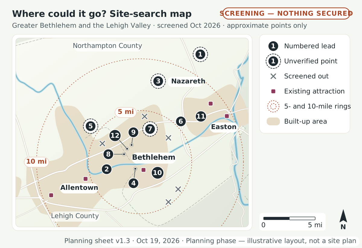 (opens the full-size drawing in a new tab)
Key, legend and notes
Key
- 1Gall Farm Preserve (county “Gall Road” land): Low · about 149 (149.15 ac, Parcels A–E, 2024 council packet) · approximate point, not a parcel · Plainfield Twp · reference only · about 12 mi straight-line from central Bethlehem
- 2Former Allentown State Hospital (“Northridge”): Medium · about 195 total; at least 70 ac kept for outdoor recreation; about 46% open space in 2024 master plan
- 3Gracedale county campus: Medium · 365 · approximate point, not a parcel
- 4Bethlehem city parks (pilot pieces only): High for pilots / Low for rides · 722.23 ac of parks, 11.86 mi of trails (individual sites smaller)
- 5Wayne A. Grube Memorial Park: Medium (programs) · about 200 · approximate point, not a parcel
- 6Louise W. Moore Park: Low–Medium · about 100
- 7Housenick Park & Archibald Johnston Conservation Area: Low · 55.84 (township) + 36–48 (county) · approximate point, not a parcel
- 8Former Martin Tower site (“Tower Place”): Low–Medium · about 53
- 9Bethlehem Golf Club: Low–Medium · Unknown (18-hole par-71 course, 9-hole executive course, range)
- 10Former Bethlehem Steel lands east of SteelStacks: Low · Wind Creek 56; Majestic 440+; LVIP VII lots
- 11Palmer Park Mall (former Bon-Ton building): Medium (indoor only) · 100,000+ sq ft building (land unknown)
- 12Westgate Mall: Low · about 22
Legend
- Numbered lead
- Shortlisted lead, numbered as in the key. Where leads crowd, the number sits to one side with a thin line to a small dot at the approximate point.
- Unverified point
- A number inside a dashed ring marks an approximate point from a third-party listing (unverified)
- Screened out
- A small cross marks an area screened out (sold, cleared for other uses, in litigation, or preserved)
- Existing attraction
- A small square marks an existing attraction (competitor or complement)
- 5- and 10-mile rings
- Dotted rings 5 and 10 miles (straight line) from central Bethlehem
- Built-up area
- Soft tan shading marks built-up land (Natural Earth, generalized)
- Base data: U.S. Census Bureau county boundaries via us-atlas (1:10m); Natural Earth 1:10m rivers, roads and urban areas (public domain), generalized and smoothed for readability.
- Site points are approximate centroids from public descriptions; the Gall Farm Preserve point comes from a third-party listing and is unverified.
- Parcel boundaries, ownership and zoning must be confirmed with Lehigh and Northampton County assessment and GIS offices before any outreach. Planning phase: no site is owned or confirmed in writing.
How this was made
We prepared the research, writing, drawings and website code with help from an AI assistant, Claude, made by Anthropic. The assistant worked with the organizer, David Fischbarg.
AI tools can make mistakes, and so can people. That is one more reason we list every source. If a link is broken, a fact is out of date or we misread a source, please tell us. Name the page and the source if you can. We will check it and correct the brief and this site.