Stage: Planning phase · Independent project
Possible Locations
Please read first: no site is confirmed
- The main location is being finalized, and no landowner has confirmed a site in writing. The areas on this page are research, not choices. This page does not say whether any of them is the location being finalized.
- Nothing has been agreed in writing with the City or with any landowner or agency. Being listed here does not mean an owner is interested, or that a place is for sale or open to a park.
- Points on the map are approximate, for orientation only. They are not parcel boundaries.
- Please do not contact owners or agencies on the project’s behalf. If you know something about a place, tell us instead.
How we searched
We screened each area with seven questions, using web searches of public sources on October 18, 2026. We could not open county parcel maps, FEMA flood maps, municipal websites or full documents from our research setup. That is why many answers are still unknown.
Two of the project’s four tests matter most here: less wasteful (reuse an existing or under-used site before taking new land) and more accessible (places people can reach by bus, by trail or on foot).
Land availability and control
Is the land really available, or does it only look empty?
Size fit
Is it big enough for a Small Public Discovery Park (A), a Family Attraction Park (B) or a Larger Regional Park (C)?
Environmental limits
Is there flooding, wetland, old pollution, protected wildlife or preserved farmland?
Access
Can people get there by road, by LANta bus, by trail or on foot?
Utilities
Are public water, sewer and power likely to be nearby?
Neighbors
Would noise, traffic and lights fit with the people who live and work nearby?
Fit with plans and deeds
Do adopted plans, zoning and any deed or gift terms allow a park like this?
How each answer is scored
- 3
- Favorable
- 2
- Workable
- 1
- Difficult
- 0
- Blocking
- ?
- Unknown
Scores are not added up
One blocking problem can outweigh several good answers, so a total would hide what matters. The scores are judgments to guide our questions. They are not findings. An unknown stays unknown and never counts as zero.
A regional lens: keep family places away from industry
We follow a simple regional idea: different parts of the region get different jobs, and public family places stay apart from industrial sites that could be hazardous. This matches our screening: airport and warehouse land was set aside, and former Steel land cleaned only to nonresidential standards rates low for children’s play.
Map and comparison
The map shows roughly where each area is, with the same numbers used on this page. It is a planning sheet, for research only. The table under it gives each area’s seven scores in words.
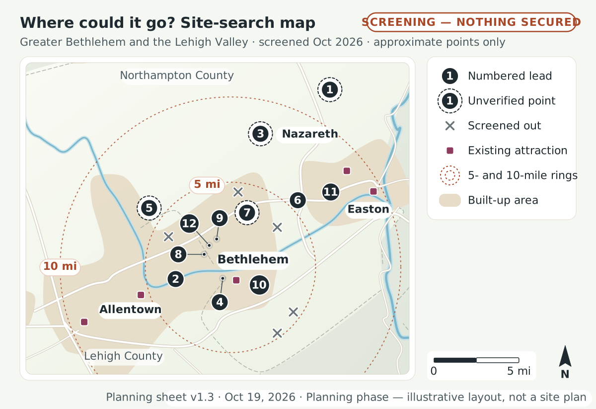 (opens the full-size drawing in a new tab)
Key, legend and notes
Key
- 1Gall Farm Preserve (county “Gall Road” land): Low · about 149 (149.15 ac, Parcels A–E, 2024 council packet) · approximate point, not a parcel · Plainfield Twp · reference only · about 12 mi straight-line from central Bethlehem
- 2Former Allentown State Hospital (“Northridge”): Medium · about 195 total; at least 70 ac kept for outdoor recreation; about 46% open space in 2024 master plan
- 3Gracedale county campus: Medium · 365 · approximate point, not a parcel
- 4Bethlehem city parks (pilot pieces only): High for pilots / Low for rides · 722.23 ac of parks, 11.86 mi of trails (individual sites smaller)
- 5Wayne A. Grube Memorial Park: Medium (programs) · about 200 · approximate point, not a parcel
- 6Louise W. Moore Park: Low–Medium · about 100
- 7Housenick Park & Archibald Johnston Conservation Area: Low · 55.84 (township) + 36–48 (county) · approximate point, not a parcel
- 8Former Martin Tower site (“Tower Place”): Low–Medium · about 53
- 9Bethlehem Golf Club: Low–Medium · Unknown (18-hole par-71 course, 9-hole executive course, range)
- 10Former Bethlehem Steel lands east of SteelStacks: Low · Wind Creek 56; Majestic 440+; LVIP VII lots
- 11Palmer Park Mall (former Bon-Ton building): Medium (indoor only) · 100,000+ sq ft building (land unknown)
- 12Westgate Mall: Low · about 22
Legend
- Numbered lead
- Shortlisted lead, numbered as in the key. Where leads crowd, the number sits to one side with a thin line to a small dot at the approximate point.
- Unverified point
- A number inside a dashed ring marks an approximate point from a third-party listing (unverified)
- Screened out
- A small cross marks an area screened out (sold, cleared for other uses, in litigation, or preserved)
- Existing attraction
- A small square marks an existing attraction (competitor or complement)
- 5- and 10-mile rings
- Dotted rings 5 and 10 miles (straight line) from central Bethlehem
- Built-up area
- Soft tan shading marks built-up land (Natural Earth, generalized)
- Base data: U.S. Census Bureau county boundaries via us-atlas (1:10m); Natural Earth 1:10m rivers, roads and urban areas (public domain), generalized and smoothed for readability.
- Site points are approximate centroids from public descriptions; the Gall Farm Preserve point comes from a third-party listing and is unverified.
- Parcel boundaries, ownership and zoning must be confirmed with Lehigh and Northampton County assessment and GIS offices before any outreach. Planning phase: no site is owned or confirmed in writing.
The comparison scores in words
“Unknown” means we could not find out yet. See how each answer is scored.
1. Gall Farm Preserve (county “Gall Road” land)
Outlook: Low
- Land availability
- 0 Blocking
- Size fit
- 3 Favorable
- Environment
- 1 Difficult
- Access
- 1 Difficult
- Utilities
- Unknown
- Neighbors
- Unknown
- Plans and deeds
- 1 Difficult
2. Former Allentown State Hospital (“Northridge”)
Outlook: Medium
- Land availability
- 1 Difficult
- Size fit
- 3 Favorable
- Environment
- 2 Workable
- Access
- 2 Workable
- Utilities
- 2 Workable
- Neighbors
- 1 Difficult
- Plans and deeds
- 2 Workable
3. Gracedale county campus
Outlook: Medium
- Land availability
- 1 Difficult
- Size fit
- 3 Favorable
- Environment
- Unknown
- Access
- 2 Workable
- Utilities
- 2 Workable
- Neighbors
- 2 Workable
- Plans and deeds
- 1 Difficult
4. Bethlehem city parks (pilot pieces only)
Outlook: High for pilots / Low for rides
- Land availability
- 2 Workable
- Size fit
- 1 Difficult
- Environment
- 1 Difficult
- Access
- 3 Favorable
- Utilities
- 3 Favorable
- Neighbors
- 2 Workable
- Plans and deeds
- 3 Favorable
5. Wayne A. Grube Memorial Park
Outlook: Medium (programs)
- Land availability
- 2 Workable
- Size fit
- 3 Favorable
- Environment
- Unknown
- Access
- 1 Difficult
- Utilities
- Unknown
- Neighbors
- 2 Workable
- Plans and deeds
- 2 Workable
6. Louise W. Moore Park
Outlook: Low–Medium
- Land availability
- 1 Difficult
- Size fit
- 3 Favorable
- Environment
- Unknown
- Access
- 2 Workable
- Utilities
- Unknown
- Neighbors
- 2 Workable
- Plans and deeds
- 1 Difficult
7. Housenick Park and Archibald Johnston Conservation Area
Outlook: Low
- Land availability
- 0 Blocking
- Size fit
- 2 Workable
- Environment
- 1 Difficult
- Access
- 2 Workable
- Utilities
- Unknown
- Neighbors
- 2 Workable
- Plans and deeds
- 0 Blocking
8. Former Martin Tower site (“Tower Place”)
Outlook: Low–Medium
- Land availability
- 1 Difficult
- Size fit
- 1 Difficult
- Environment
- Unknown
- Access
- 3 Favorable
- Utilities
- 3 Favorable
- Neighbors
- 2 Workable
- Plans and deeds
- 1 Difficult
9. Bethlehem Golf Club
Outlook: Low–Medium
- Land availability
- 1 Difficult
- Size fit
- Unknown
- Environment
- Unknown
- Access
- 2 Workable
- Utilities
- 3 Favorable
- Neighbors
- 2 Workable
- Plans and deeds
- 1 Difficult
10. Former Bethlehem Steel lands east of SteelStacks
Outlook: Low
- Land availability
- 0 Blocking
- Size fit
- 2 Workable
- Environment
- 0 Blocking
- Access
- 3 Favorable
- Utilities
- 3 Favorable
- Neighbors
- 3 Favorable
- Plans and deeds
- 1 Difficult
11. Palmer Park Mall (former Bon-Ton building)
Outlook: Medium (indoor only)
- Land availability
- 2 Workable
- Size fit
- 1 Difficult
- Environment
- 3 Favorable
- Access
- 3 Favorable
- Utilities
- 3 Favorable
- Neighbors
- 3 Favorable
- Plans and deeds
- 2 Workable
12. Westgate Mall
Outlook: Low
- Land availability
- 0 Blocking
- Size fit
- 0 Blocking
- Environment
- 3 Favorable
- Access
- 3 Favorable
- Utilities
- 3 Favorable
- Neighbors
- 3 Favorable
- Plans and deeds
- 1 Difficult
1. Gall Farm Preserve (county “Gall Road” land)
- Land availability
- 0 Blocking
- Size fit
- 3 Favorable
- Environment
- 1 Difficult
- Access
- 1 Difficult
- Utilities
- Unknown
- Neighbors
- Unknown
- Plans and deeds
- 1 Difficult
- Outlook
- Low
2. Former Allentown State Hospital (“Northridge”)
- Land availability
- 1 Difficult
- Size fit
- 3 Favorable
- Environment
- 2 Workable
- Access
- 2 Workable
- Utilities
- 2 Workable
- Neighbors
- 1 Difficult
- Plans and deeds
- 2 Workable
- Outlook
- Medium
3. Gracedale county campus
- Land availability
- 1 Difficult
- Size fit
- 3 Favorable
- Environment
- Unknown
- Access
- 2 Workable
- Utilities
- 2 Workable
- Neighbors
- 2 Workable
- Plans and deeds
- 1 Difficult
- Outlook
- Medium
4. Bethlehem city parks (pilot pieces only)
- Land availability
- 2 Workable
- Size fit
- 1 Difficult
- Environment
- 1 Difficult
- Access
- 3 Favorable
- Utilities
- 3 Favorable
- Neighbors
- 2 Workable
- Plans and deeds
- 3 Favorable
- Outlook
- High for pilots / Low for rides
5. Wayne A. Grube Memorial Park
- Land availability
- 2 Workable
- Size fit
- 3 Favorable
- Environment
- Unknown
- Access
- 1 Difficult
- Utilities
- Unknown
- Neighbors
- 2 Workable
- Plans and deeds
- 2 Workable
- Outlook
- Medium (programs)
6. Louise W. Moore Park
- Land availability
- 1 Difficult
- Size fit
- 3 Favorable
- Environment
- Unknown
- Access
- 2 Workable
- Utilities
- Unknown
- Neighbors
- 2 Workable
- Plans and deeds
- 1 Difficult
- Outlook
- Low–Medium
7. Housenick Park and Archibald Johnston Conservation Area
- Land availability
- 0 Blocking
- Size fit
- 2 Workable
- Environment
- 1 Difficult
- Access
- 2 Workable
- Utilities
- Unknown
- Neighbors
- 2 Workable
- Plans and deeds
- 0 Blocking
- Outlook
- Low
8. Former Martin Tower site (“Tower Place”)
- Land availability
- 1 Difficult
- Size fit
- 1 Difficult
- Environment
- Unknown
- Access
- 3 Favorable
- Utilities
- 3 Favorable
- Neighbors
- 2 Workable
- Plans and deeds
- 1 Difficult
- Outlook
- Low–Medium
9. Bethlehem Golf Club
- Land availability
- 1 Difficult
- Size fit
- Unknown
- Environment
- Unknown
- Access
- 2 Workable
- Utilities
- 3 Favorable
- Neighbors
- 2 Workable
- Plans and deeds
- 1 Difficult
- Outlook
- Low–Medium
10. Former Bethlehem Steel lands east of SteelStacks
- Land availability
- 0 Blocking
- Size fit
- 2 Workable
- Environment
- 0 Blocking
- Access
- 3 Favorable
- Utilities
- 3 Favorable
- Neighbors
- 3 Favorable
- Plans and deeds
- 1 Difficult
- Outlook
- Low
11. Palmer Park Mall (former Bon-Ton building)
- Land availability
- 2 Workable
- Size fit
- 1 Difficult
- Environment
- 3 Favorable
- Access
- 3 Favorable
- Utilities
- 3 Favorable
- Neighbors
- 3 Favorable
- Plans and deeds
- 2 Workable
- Outlook
- Medium (indoor only)
12. Westgate Mall
- Land availability
- 0 Blocking
- Size fit
- 0 Blocking
- Environment
- 3 Favorable
- Access
- 3 Favorable
- Utilities
- 3 Favorable
- Neighbors
- 3 Favorable
- Plans and deeds
- 1 Difficult
- Outlook
- Low
| Area | Land availability | Size fit | Environment | Access | Utilities | Neighbors | Plans and deeds | Outlook |
|---|---|---|---|---|---|---|---|---|
| 1. Gall Farm Preserve (county “Gall Road” land) | 0 Blocking | 3 Favorable | 1 Difficult | 1 Difficult | Unknown | Unknown | 1 Difficult | Low |
| 2. Former Allentown State Hospital (“Northridge”) | 1 Difficult | 3 Favorable | 2 Workable | 2 Workable | 2 Workable | 1 Difficult | 2 Workable | Medium |
| 3. Gracedale county campus | 1 Difficult | 3 Favorable | Unknown | 2 Workable | 2 Workable | 2 Workable | 1 Difficult | Medium |
| 4. Bethlehem city parks (pilot pieces only) | 2 Workable | 1 Difficult | 1 Difficult | 3 Favorable | 3 Favorable | 2 Workable | 3 Favorable | High for pilots / Low for rides |
| 5. Wayne A. Grube Memorial Park | 2 Workable | 3 Favorable | Unknown | 1 Difficult | Unknown | 2 Workable | 2 Workable | Medium (programs) |
| 6. Louise W. Moore Park | 1 Difficult | 3 Favorable | Unknown | 2 Workable | Unknown | 2 Workable | 1 Difficult | Low–Medium |
| 7. Housenick Park and Archibald Johnston Conservation Area | 0 Blocking | 2 Workable | 1 Difficult | 2 Workable | Unknown | 2 Workable | 0 Blocking | Low |
| 8. Former Martin Tower site (“Tower Place”) | 1 Difficult | 1 Difficult | Unknown | 3 Favorable | 3 Favorable | 2 Workable | 1 Difficult | Low–Medium |
| 9. Bethlehem Golf Club | 1 Difficult | Unknown | Unknown | 2 Workable | 3 Favorable | 2 Workable | 1 Difficult | Low–Medium |
| 10. Former Bethlehem Steel lands east of SteelStacks | 0 Blocking | 2 Workable | 0 Blocking | 3 Favorable | 3 Favorable | 3 Favorable | 1 Difficult | Low |
| 11. Palmer Park Mall (former Bon-Ton building) | 2 Workable | 1 Difficult | 3 Favorable | 3 Favorable | 3 Favorable | 3 Favorable | 2 Workable | Medium (indoor only) |
| 12. Westgate Mall | 0 Blocking | 0 Blocking | 3 Favorable | 3 Favorable | 3 Favorable | 3 Favorable | 1 Difficult | Low |
The twelve areas
The areas are listed in the same order and with the same numbers as the map. This is not a ranking. The outlook is our rough judgment of whether a piece of the park could fit there, based only on public sources.
Each card shows how sure we are. Fact-checked means a second, independent search confirmed or corrected it. Verified means it comes from an official or primary source. Reported means it comes from news or another secondary source. Every source was read as a search extract and must be opened again before anyone relies on it.
1. Gall Farm Preserve (county “Gall Road” land)
Outlook: LowVerifiedReference only: the county has its own plans.
- Where
- Plainfield Township (Northampton County)Approximate point from a third-party listing (reported, unverified). It is not a parcel boundary.
- Size
- About 149 acres (149.15 acres, Parcels A–E, 2024 council packet)
- Owner
- Northampton County
- What we found
- Bought by the county in 2003 “to be developed into a regional park”. Leased farmland, woodlands and the Little Bushkill Creek, with steep slopes east of the stream; the Plainfield Township Recreation Trail runs through its western part; an active county hunting area. The county’s own steps: a $300,000 DCNR C2P2 award in Sept 2022 (reported); a Phase 1A reported as a parking lot, stormwater control and a trail connection; a June 2024 council resolution supporting a Phase I development grant application. Whether anything has been built is unknown; no 2025–26 news found. About 12 miles straight-line from central Bethlehem (estimate). We treat it as a county project to learn from, not a target for this park.
Scores, unknowns, next step and sources
- Scores (5 of 7 known)
- Land availability
- 0 Blocking
- Size fit
- 3 Favorable
- Environment
- 1 Difficult
- Access
- 1 Difficult
- Utilities
- Unknown
- Neighbors
- Unknown
- Plans and deeds
- 1 Difficult
- Key unknowns
- What the county has built or scheduled since 2024
- Whether the 2019 master site development plan is still current
- Deed and grant terms; parcel boundaries (only a third-party map point is known)
- Preserved-farmland or Agricultural Security Area status
- FEMA flood zones along the creek
- Which electric utility serves it (PPL or Met-Ed)
- Possible next step (not taken yet)
- See Next inquiries, step 4
- Sources
- Northampton County Parks and Recreation (norcopa.gov) (opens in a new tab)
- Gall Farm Preserve: county hunting areas (norcopa.gov) (opens in a new tab)
- Gall Farm Preserve acreage: Northampton County Council agenda packet (Mar 7, 2024), on norcopa.gov (opens in a new tab)
- Gall Farm Preserve Phase I grant: Northampton County Council agenda (June 2024), on norcopa.gov (opens in a new tab)
- Gall Farm Preserve state recreation award (2022), on lvpnews.com (opens in a new tab)
- Gall Farm Preserve, Valley Ledger report (thevalleyledger.com) (opens in a new tab)
- Plainfield Township minutes (Feb 17, 2022), on plainfieldtownship.org (opens in a new tab)
2. Former Allentown State Hospital (“Northridge”)
Outlook: MediumFact-checkedCould fit Scale A/B inside the required open space, by partnership.
- Where
- City of Allentown (east side)
- Size
- About 195 acres total; at least 70 acres kept for outdoor recreation; about 46% open space in 2024 master plan
- Owner
- City Center (private), bought Sept 2022
- What we found
- A new zoning district for mixed uses was adopted in 2023 (4–3 vote); master plan and about 202,000 sq ft K-8 school cleared; about 10-year buildout with 1,000+ homes; open space mostly by the Lehigh River.
Scores, unknowns, next step and sources
- Scores (7 of 7 known)
- Land availability
- 1 Difficult
- Size fit
- 3 Favorable
- Environment
- 2 Workable
- Access
- 2 Workable
- Utilities
- 2 Workable
- Neighbors
- 1 Difficult
- Plans and deeds
- 2 Workable
- Key unknowns
- Open-space layout and future owner
- Floodplain along the river
- Whether rides fit next to new homes and a school
- Possible next step (not taken yet)
- See Next inquiries, step 3
3. Gracedale county campus
Outlook: MediumFact-checkedCould fit Scale A/B/C, subject to the county plan.
- Where
- Upper Nazareth TownshipApproximate point from USGS GNIS ‘Gracedale County Home’ (via TopoQuest; search extract, Oct 2026).
- Size
- 365 acres
- Owner
- Northampton County
- What we found
- 2026 County Executive plan: about 700-bed nursing facility, medical offices, dialysis, workforce housing, retail; meant to pay for itself. Nursing home has a one-star Medicare rating and provisional license; council created a Gracedale department (5–4 vote). No vote on the campus plan.
Scores, unknowns, next step and sources
- Scores (6 of 7 known)
- Land availability
- 1 Difficult
- Size fit
- 3 Favorable
- Environment
- Unknown
- Access
- 2 Workable
- Utilities
- 2 Workable
- Neighbors
- 2 Workable
- Plans and deeds
- 1 Difficult
- Key unknowns
- Zoning
- Preserved-farmland or Agricultural Security Area status, wetlands, deed terms
- Timeline of county plan
- Water and sewer capacity beyond the nursing home
- Possible next step (not taken yet)
- See Next inquiries, step 3
4. Bethlehem city parks (pilot pieces only)
Outlook: High for pilots / Low for ridesFact-checkedCould fit Scale A as pilot pieces and pop-up events.
- Where
- City of Bethlehem
- Size
- 722.23 acres of parks, 11.86 miles of trails (individual sites smaller)
- Owner
- City of Bethlehem
- What we found
- “40 in 10” master plan complete; implementation began March 18, 2026; 4,000+ people engaged; total plan cost unknown. Demand for inclusive and natural play and splash pads. Sand Island, Monocacy and Saucon parks flood (reported); the city will not rebuild the Saucon pool in the floodplain. The flooding at these parks is reported in news sources.
Scores, unknowns, next step and sources
- Scores (7 of 7 known)
- Land availability
- 2 Workable
- Size fit
- 1 Difficult
- Environment
- 1 Difficult
- Access
- 3 Favorable
- Utilities
- 3 Favorable
- Neighbors
- 2 Workable
- Plans and deeds
- 3 Favorable
- Key unknowns
- FEMA flood zones per park
- How a pilot fits the plan’s priorities
- Which non-flood parcels have room
- Possible next step (not taken yet)
- See Next inquiries, step 3
5. Wayne A. Grube Memorial Park
Outlook: Medium (programs)VerifiedCould fit Scale A as programs; rides are unlikely.
- Where
- Allen TownshipApproximate point from the county’s published GPS coordinates for the park (search extract, Oct 2026).
- Size
- About 200 acres
- Owner
- Northampton County
- What we found
- Existing county park with playground, softball field and pavilions.
Scores, unknowns, next step and sources
- Scores (5 of 7 known)
- Land availability
- 2 Workable
- Size fit
- 3 Favorable
- Environment
- Unknown
- Access
- 1 Difficult
- Utilities
- Unknown
- Neighbors
- 2 Workable
- Plans and deeds
- 2 Workable
- Key unknowns
- Master plan
- Utilities
- Deed or grant limits
- Possible next step (not taken yet)
Ask county about program partnerships and long-range plans.
6. Louise W. Moore Park
Outlook: Low–MediumVerifiedCould fit Scale A as nature and learning programs.
- Where
- Bethlehem and Lower Nazareth Townships
- Size
- About 100 acres
- Owner
- Northampton County
- What we found
- Donated in 1973 “to be developed as passive parkland”.
Scores, unknowns, next step and sources
- Scores (5 of 7 known)
- Land availability
- 1 Difficult
- Size fit
- 3 Favorable
- Environment
- Unknown
- Access
- 2 Workable
- Utilities
- Unknown
- Neighbors
- 2 Workable
- Plans and deeds
- 1 Difficult
- Key unknowns
- Exact deed language
- Master plan
- Possible next step (not taken yet)
Explore nature-education partnership only.
7. Housenick Park and Archibald Johnston Conservation Area
Outlook: LowVerifiedPossible fit: nature-education partner only.
- Where
- Bethlehem TownshipApproximate point from the 3811 Christian Spring Rd GPS listing (Wildlands Conservancy; search extract, Oct 2026).
- Size
- 55.84 acres (township) + 36–48 acres (county)
- Owner
- Bethlehem Township (the park) and Northampton County (the conservation area)
- What we found
- Township park is “solely for passive recreational activities”; a Natural Heritage Area.
Scores, unknowns, next step and sources
- Scores (6 of 7 known)
- Land availability
- 0 Blocking
- Size fit
- 2 Workable
- Environment
- 1 Difficult
- Access
- 2 Workable
- Utilities
- Unknown
- Neighbors
- 2 Workable
- Plans and deeds
- 0 Blocking
- Key unknowns
- Bequest terms in detail
- Possible next step (not taken yet)
Possible partner for guided nature programs.
8. Former Martin Tower site (“Tower Place”)
Outlook: Low–MediumFact-checkedPossible fit: small urban play space at most.
- Where
- City of Bethlehem
- Size
- About 53 acres
- Owner
- Private
- What we found
- Lehigh Valley Health Network health buildings opened 2025. Plan cleared Feb 2023 for 1,085 apartments, 200-room hotel and medical offices; a section left for “future development”. No evidence that apartment or hotel construction had begun by 2026.
Scores, unknowns, next step and sources
- Scores (6 of 7 known)
- Land availability
- 1 Difficult
- Size fit
- 1 Difficult
- Environment
- Unknown
- Access
- 3 Favorable
- Utilities
- 3 Favorable
- Neighbors
- 2 Workable
- Plans and deeds
- 1 Difficult
- Key unknowns
- Size of the future-development section
- Whether housing has started
- Possible next step (not taken yet)
Ask whether a public play or green space is planned in the housing phases.
9. Bethlehem Golf Club
Outlook: Low–MediumVerifiedCould fit Scale B, only if the city changed the course use.
- Where
- City of Bethlehem
- Size
- Unknown (18-hole par-71 course, 9-hole executive course, range)
- Owner
- City of Bethlehem
- What we found
- City is reinvesting: 2026 proposed golf fund $3.86 million including $2.04 million equipment (vote not confirmed).
Scores, unknowns, next step and sources
- Scores (5 of 7 known)
- Land availability
- 1 Difficult
- Size fit
- Unknown
- Environment
- Unknown
- Access
- 2 Workable
- Utilities
- 3 Favorable
- Neighbors
- 2 Workable
- Plans and deeds
- 1 Difficult
- Key unknowns
- Acreage
- FEMA flood zones
- Council intentions
- Possible next step (not taken yet)
No action unless the city reconsiders golf operations.
10. Former Bethlehem Steel lands east of SteelStacks
Outlook: LowFact-checkedPossible fit: indoor partnership idea only.
- Where
- City of Bethlehem (South Side)
- Size
- Wind Creek 56 acres; Majestic 440+ acres; LVIP VII lots (one cleared for warehouses)
- Owner
- Private
- What we found
- Cleanup to nonresidential standards with recorded covenants (2001 onward). LVIP VII lot cleared for warehouses (2025). Wind Creek’s 2019 indoor water-park idea (about 300,000 sq ft, $100 million pledge) later described as ‘fluid’; no 2024–26 approval found.
Scores, unknowns, next step and sources
- Scores (7 of 7 known)
- Land availability
- 0 Blocking
- Size fit
- 2 Workable
- Environment
- 0 Blocking
- Access
- 3 Favorable
- Utilities
- 3 Favorable
- Neighbors
- 3 Favorable
- Plans and deeds
- 1 Difficult
- Key unknowns
- Covenant text per parcel
- Remaining undeveloped acreage
- Wind Creek intentions
- Possible next step (not taken yet)
None for now. Children’s play on soil cleaned only to nonresidential standards would need review by the state Department of Environmental Protection (DEP), so we do not recommend it.
See also Next inquiries, step 3
11. Palmer Park Mall (former Bon-Ton building)
Outlook: Medium (indoor only)ReportedPossible fit: indoor four-season piece only, as an option for the four-season Discovery Hall Scale C
- Where
- Palmer Township
- Size
- 100,000+ sq ft building (land unknown)
- Owner
- Private
- What we found
- Vacant anchor marketed for redevelopment including entertainment.
Scores, unknowns, next step and sources
- Scores (7 of 7 known)
- Land availability
- 2 Workable
- Size fit
- 1 Difficult
- Environment
- 3 Favorable
- Access
- 3 Favorable
- Utilities
- 3 Favorable
- Neighbors
- 3 Favorable
- Plans and deeds
- 2 Workable
- Key unknowns
- Owner, rent, zoning for amusement use
- Possible next step (not taken yet)
- See Next inquiries, step 3
12. Westgate Mall
Outlook: LowReportedPossible fit: none (fully redeveloped).
- Where
- City of Bethlehem
- Size
- About 22 acres
- Owner
- Private
- What we found
- $20 million redevelopment done; listed for sale 84% leased.
Scores, unknowns, next step and sources
- Scores (7 of 7 known)
- Land availability
- 0 Blocking
- Size fit
- 0 Blocking
- Environment
- 3 Favorable
- Access
- 3 Favorable
- Utilities
- 3 Favorable
- Neighbors
- 3 Favorable
- Plans and deeds
- 1 Difficult
- Key unknowns
- Sale outcome
- Possible next step (not taken yet)
None.
Places we set aside
These places looked possible at first. We set them aside because they are sold, used for other things, in court or protected as preserves.
Dutch Springs / Lake Hydra
- Why we set it aside
- Sold 2022 ($16.1 million) for about 588,000 sq ft of warehouses; quarry for dive training only.
Lehigh Valley International Airport land
- Why we set it aside
- Sold or leased for industrial use. Federal Aviation Administration approval is needed to release federally funded land.
Bethlehem Landfill expansion area
- Why we set it aside
- In litigation over rezoning and conservation easements.
Willow Brook and Green Pond golf lands
- Why we set it aside
- Housing built or proposed.
Woodland Hills Preserve
- Why we set it aside
- Township-owned passive preserve bought with grants.
South Mall / Phillipsburg Mall / Whitehall Plaza
- Why we set it aside
- Being re-tenanted or replaced by warehouses.
| Area | Why we set it aside | Source |
|---|---|---|
| Dutch Springs / Lake Hydra | Sold 2022 ($16.1 million) for about 588,000 sq ft of warehouses; quarry for dive training only. | Dutch Springs sale (wfmz.com) (opens in a new tab) |
| Lehigh Valley International Airport land | Sold or leased for industrial use. Federal Aviation Administration approval is needed to release federally funded land. | Airport (ABE) land sale (flyabe.com) (opens in a new tab) |
| Bethlehem Landfill expansion area | In litigation over rezoning and conservation easements. | Bethlehem Landfill appeal (lehighvalleynews.com) (opens in a new tab) |
| Willow Brook and Green Pond golf lands | Housing built or proposed. | Willow Brook Farms housing proposal, Allen Township (2022 hearing), on wfmz.com (opens in a new tab) |
| Woodland Hills Preserve | Township-owned passive preserve bought with grants. | Woodland Hills (lowersaucontownship.org) (opens in a new tab) |
| South Mall / Phillipsburg Mall / Whitehall Plaza | Being re-tenanted or replaced by warehouses. | Phillipsburg redevelopment report (nj.gov) (opens in a new tab) |
We also set aside Bushkill Park in Forks Township. It is an operating private historic park in a floodplain (reported). We see it as an example to learn from, not a site, and we have not contacted it. Source: WFMZ report on Bushkill Park’s anniversary (opens in a new tab).
We left SteelStacks out of the search on purpose, as the project’s owner asked. The “former Bethlehem Steel lands east of SteelStacks” (area 10) are a different place.
What is unknown for every site
These must be checked before any place is discussed publicly as a candidate. Before any outreach, we would confirm these facts with the county assessment and mapping offices in Lehigh and Northampton counties. We would also check with the town or city involved.
- Boundaries and ownership
- Exact parcel lines and owners, from county assessment records and county maps.
- Zoning
- Whether an amusement or commercial recreation use is allowed outright, allowed with conditions, or needs a special exception.
- Flooding
- FEMA flood zones and floodways. The Lehigh River and the Monocacy, Saucon and Bushkill creeks all flood. The state emergency agency, PEMA, updated its floodplain development guide in June 2025.
- Wetlands and wildlife
- Wetlands, from the National Wetlands Inventory and a check on the ground, and protected species, from a Pennsylvania Natural Diversity Inventory search.
- Preserved farmland
- Preserved farms and Agricultural Security Areas. Preserved farms generally carry permanent agricultural easements, legal promises that keep the land in farming, so we treat them as unavailable.
- Old industrial pollution
- Cleanup covenants under Pennsylvania’s Act 2, which are recorded limits on how cleaned-up land may be used. The state Department of Environmental Protection (DEP) notes that a playground likely needs land cleaned to near-residential standards.
- Utilities
- Water, sewer (including local Act 537 sewage plans), and electric service and capacity. The electric utility is PPL or Met-Ed (now part of FirstEnergy Pennsylvania), depending on the exact parcel.
- Traffic, noise and neighbors
- How visitors would arrive, how much sound would carry, and how nearby homes and businesses would feel about it.
How much land?
We do not know the exact size a park would need. To estimate it, we drew each size to scale on a made-up rectangular parcel and measured the result. These are test fits on sample parcels (illustrative, not site plans). The real need depends on a site’s shape, slopes, floodplain, buffers, parking and the program chosen.
See the test-fit plans for all three sizes on the Experiences page
Scale ASmall Public Discovery Park (pilot)
- Planning range
- About 5–15 acres
- Test-fit parcel
- 830 × 525 ft (about 253 × 160 m), 10.0 acres
- Parking in the test fit
- 0.78 acres, about 100 spaces
- Paths, buffers and stormwater
- 3.35 acres (34%)
Scale BFamily Attraction Park
- Planning range
- About 20–35 acres
- Test-fit parcel
- 1,250 × 975 ft (about 381 × 297 m), 28.0 acres
- Parking in the test fit
- 4.16 acres, about 360 paved and 190 grass spaces
- Paths, buffers and stormwater
- 8.25 acres (29%)
Scale CLarger Regional Park (only if justified)
- Planning range
- About 50–120 acres
- Test-fit parcel
- 2,000 × 1,630 ft (about 610 × 497 m), 74.8 acres
- Parking in the test fit
- Adds an 8.0-acre festival and overflow meadow
- Paths, buffers and stormwater
- Adds 8.1 acres
| Park size | Planning range | Test-fit parcel | Parking in the test fit | Paths, buffers and stormwater |
|---|---|---|---|---|
| Scale ASmall Public Discovery Park (pilot) | About 5–15 acres | 830 × 525 ft (about 253 × 160 m), 10.0 acres | 0.78 acres, about 100 spaces | 3.35 acres (34%) |
| Scale BFamily Attraction Park | About 20–35 acres | 1,250 × 975 ft (about 381 × 297 m), 28.0 acres | 4.16 acres, about 360 paved and 190 grass spaces | 8.25 acres (29%) |
| Scale CLarger Regional Park (only if justified) | About 50–120 acres | 2,000 × 1,630 ft (about 610 × 497 m), 74.8 acres | Adds an 8.0-acre festival and overflow meadow | Adds 8.1 acres |
What could make each size need less land or more land
Small Public Discovery Park (pilot)
- Less land if
- It is attached to an existing park and shares its parking.
- More land if
- The site has steep slopes, a stream or an irregular shape.
Family Attraction Park
- Less land if
- Parking is shared or served by a shuttle, and the ride area is compact.
- More land if
- It needs event parking on site, wide buffers next to neighbors, or a train loop.
Larger Regional Park (only if justified)
- Less land if
- The site already holds protected woods or wetlands.
- More land if
- It adds amphitheater events and a four-season Discovery Hall.
Key planning assumptions
Assumption- Parking. About 330 sq ft per space, including the driving aisles. That is about 130 spaces per acre, so every 100 spaces takes about ¾ acre. Parking is the biggest single reason the land needed goes up or down.
- Buffers. A planted buffer of 25–100 ft next to neighbors. Stormwater and landscape margins take 15–35% of a site.
- Design day for Scale B. 3,000–5,000 guests on a busy day, with about 60% in the park at the same time. We use this for sizing only. A market study would have to set the real number.
- Lawn events. 15–25 sq ft per person seated on blankets. Event permits set the actual limits.
- Fire lanes. At least 20 ft wide with 13 ft 6 in of clearance overhead, under International Fire Code §503 where it is locally adopted.
Sharing saves land
Parking is the biggest swing factor. A park that shares parking with an existing park, or whose parking is served by a shuttle, can work on less land.
For comparison
Sizes found in our research. A scale check, not targets.
- Lehigh Valley Zoo: 29 acres (reported)Lehigh Valley Zoo (Wikipedia), on en.wikipedia.org (opens in a new tab)
- Land of Make Believe: about 30 acres (reported, low confidence)Land of Make Believe (Wikipedia), on en.wikipedia.org (opens in a new tab)
- Northridge required open space: at least 70 acres (fact-checked)Northridge master plan (lehighvalleynews.com) (opens in a new tab)
- Hersheypark: 121 acres (as of about 2015) (reported)Hersheypark acreage history (amusementparkives.com) (opens in a new tab)
- Knoebels: about 150 acres (reported)
City rules and utilities, if a site is in Bethlehem
Several areas are inside the City of Bethlehem or its sewer service area. Our research found these rules and limits. They would matter only if a site there were ever discussed. Electricity for the whole study area follows below.
Zoning
- How sure
- Fact-checked
- What we found
- The Zoning Ordinance is Part 13 of the city’s Codified Ordinances. It took effect on June 15, 2012. The latest posted revision is dated August 21, 2023. The tables of allowed uses are in Articles 1304 and 1305.
Zoning, in detail
- How sure
- Single source
- What we found
- Section 1305.01 has separate rows for indoor and outdoor commercial recreation. A use that is not listed is not allowed unless the Zoning Hearing Board grants a special exception (Section 1305.04). We have not yet read which districts allow which uses.
Food licensing
- How sure
- Fact-checked
- What we found
- The Bethlehem Health Bureau licenses and inspects places that serve food inside city limits, including mobile vendors (Article 1113, amended November 2025).
Water
- How sure
- Fact-checked
- What we found
- City water comes from the Wild Creek (1941) and Penn Forest (1958) reservoirs in Carbon and Monroe counties. Together they store about 10 billion gallons.
Water customers
- How sure
- Single source
- What we found
- About 36,400 customers at the end of 2019: 22,940 in the city and 13,496 outside it.
Wastewater
- How sure
- Fact-checked
- What we found
- The city treatment plant has a permit for 20 million gallons a day (MGD). Since 2012 it has been held to an administrative limit of 15.5 MGD because of organic loading, meaning how much waste material the water carries. A 2023 Act 537 study looked at raising that capacity.
Wastewater service area
- How sure
- Single source
- What we found
- The city plus 12 other municipalities in whole or in part, including Bethlehem Township, the Hanover Townships, Hellertown, Fountain Hill, Freemansburg, Allentown, Salisbury and Lower Saucon.
Electricity
- How sure
- Fact-checked
- What we found
- PPL Electric Utilities serves the City of Bethlehem. PPL’s Northampton County territory list names the city with no “part” note, Met-Ed’s list does not include it, and outage reports show PPL serving city customers. The PPL list we saw is a 2008 tariff supplement and may have been replaced.
Noise
- How sure
- Reported unconfirmed
- What we found
- Article 717 treats unnecessary noise as a nuisance. Secondary summaries report no numeric decibel limits. We have not read the official text.
Climate Action Plan
- How sure
- Fact-checked
- What we found
- Released April 12, 2021. Targets for community emissions, compared with 2017: 33% lower by 2025, 60% lower by 2030 and net-zero by 2040. A 2026 progress update is published.
Comprehensive Plan
- How sure
- Single source
- What we found
- The 2009 plan is the most recent. We found no named update. A separate Complete Streets Plan began asking for public input in late 2025.
| Topic | How sure | What we found |
|---|---|---|
| Zoning | Fact-checked | The Zoning Ordinance is Part 13 of the city’s Codified Ordinances. It took effect on June 15, 2012. The latest posted revision is dated August 21, 2023. The tables of allowed uses are in Articles 1304 and 1305. |
| Zoning, in detail | Single source | Section 1305.01 has separate rows for indoor and outdoor commercial recreation. A use that is not listed is not allowed unless the Zoning Hearing Board grants a special exception (Section 1305.04). We have not yet read which districts allow which uses. |
| Food licensing | Fact-checked | The Bethlehem Health Bureau licenses and inspects places that serve food inside city limits, including mobile vendors (Article 1113, amended November 2025). |
| Water | Fact-checked | City water comes from the Wild Creek (1941) and Penn Forest (1958) reservoirs in Carbon and Monroe counties. Together they store about 10 billion gallons. |
| Water customers | Single source | About 36,400 customers at the end of 2019: 22,940 in the city and 13,496 outside it. |
| Wastewater | Fact-checked | The city treatment plant has a permit for 20 million gallons a day (MGD). Since 2012 it has been held to an administrative limit of 15.5 MGD because of organic loading, meaning how much waste material the water carries. A 2023 Act 537 study looked at raising that capacity. |
| Wastewater service area | Single source | The city plus 12 other municipalities in whole or in part, including Bethlehem Township, the Hanover Townships, Hellertown, Fountain Hill, Freemansburg, Allentown, Salisbury and Lower Saucon. |
| Electricity | Fact-checked | PPL Electric Utilities serves the City of Bethlehem. PPL’s Northampton County territory list names the city with no “part” note, Met-Ed’s list does not include it, and outage reports show PPL serving city customers. The PPL list we saw is a 2008 tariff supplement and may have been replaced. |
| Noise | Reported unconfirmed | Article 717 treats unnecessary noise as a nuisance. Secondary summaries report no numeric decibel limits. We have not read the official text. |
| Climate Action Plan | Fact-checked | Released April 12, 2021. Targets for community emissions, compared with 2017: 33% lower by 2025, 60% lower by 2030 and net-zero by 2040. A 2026 progress update is published. |
| Comprehensive Plan | Single source | The 2009 plan is the most recent. We found no named update. A separate Complete Streets Plan began asking for public input in late 2025. |
Why the sewer limit matters
Any site served by the city plant would need a capacity check before restrooms, a food pavilion or a splash pad are designed.
“Single source” means it comes from an official page but was not checked again by a second search.
Sources for this table
- Bethlehem Zoning Ordinance, August 2023 (PDF) (opens in a new tab)
- Bethlehem Health Bureau food code memo, 2025 (PDF) (opens in a new tab)
- Bethlehem Authority water system history (opens in a new tab)
- Bethlehem Act 537 Special Study, 2023 (PDF) (opens in a new tab)
- Bethlehem Climate Action Plan release presentation, 2021 (PDF) (opens in a new tab)
- Bethlehem Comprehensive Plan page (opens in a new tab)
- PPL territory list, 2008 tariff supplement, PA Public Utility Commission (PDF) (opens in a new tab)
- Met-Ed territory list, PA Public Utility Commission (PDF) (opens in a new tab)
Who supplies electricity
From search results only, in October 2026. We have not contacted either utility.
Who serves the area
- How sure
- Verified
- What we found
- Two electric utilities: PPL Electric Utilities and Met-Ed. Met-Ed is now part of FirstEnergy Pennsylvania, after a merger the state utility commission cleared in December 2023. No co-op or town-run utility turned up.
Places both utilities serve
- How sure
- Verified
- What we found
- Many Northampton County townships are on both utilities’ lists, including Allen, Bethlehem Township, Lower Nazareth, Palmer, Plainfield and Upper Nazareth. There the utility depends on the exact parcel.
City of Bethlehem areas and Grube Park
- How sure
- Fact-checked
- What we found
- PPL. That covers the city parks, Tower Place, the Golf Club, the former Steel lands and Westgate. For Grube Park, a 2022 PPL right-of-way agreement covers a county parcel at the park’s address.
Northridge, Gracedale and Palmer Park Mall
- How sure
- Reported
- What we found
- Northridge: PPL, which serves Allentown. Gracedale: probably PPL, from one old news report. Palmer Park Mall: probably Met-Ed, from the township’s directory.
Moore Park, Housenick and Gall Farm
- How sure
- Unknown
- What we found
- PPL or Met-Ed. Both serve these townships, and no source ties either one to these parcels.
Capacity at any site
- How sure
- Unknown
- What we found
- Neither utility publishes how much power is available at a site. PPL discusses capacity with its business accounts team once there is a real project and an expected load.
| Topic | How sure | What we found |
|---|---|---|
| Who serves the area | Verified | Two electric utilities: PPL Electric Utilities and Met-Ed. Met-Ed is now part of FirstEnergy Pennsylvania, after a merger the state utility commission cleared in December 2023. No co-op or town-run utility turned up. |
| Places both utilities serve | Verified | Many Northampton County townships are on both utilities’ lists, including Allen, Bethlehem Township, Lower Nazareth, Palmer, Plainfield and Upper Nazareth. There the utility depends on the exact parcel. |
| City of Bethlehem areas and Grube Park | Fact-checked | PPL. That covers the city parks, Tower Place, the Golf Club, the former Steel lands and Westgate. For Grube Park, a 2022 PPL right-of-way agreement covers a county parcel at the park’s address. |
| Northridge, Gracedale and Palmer Park Mall | Reported | Northridge: PPL, which serves Allentown. Gracedale: probably PPL, from one old news report. Palmer Park Mall: probably Met-Ed, from the township’s directory. |
| Moore Park, Housenick and Gall Farm | Unknown | PPL or Met-Ed. Both serve these townships, and no source ties either one to these parcels. |
| Capacity at any site | Unknown | Neither utility publishes how much power is available at a site. PPL discusses capacity with its business accounts team once there is a real project and an expected load. |
Sources for this table
- FirstEnergy Pennsylvania merger approval (firstenergycorp.com) (opens in a new tab)
- PPL territory covered (pplelectric.com) (opens in a new tab)
- Grube Park PPL right-of-way (PUC docket U-2022-3030663), on puc.pa.gov (opens in a new tab)
- PUC filing listing PPL cities (puc.pa.gov) (opens in a new tab)
- Gracedale power outage, Hurricane Sandy (2012), on patch.com (opens in a new tab)
- Palmer Township directory (Met-Ed), on palmertwp.com (opens in a new tab)
Getting there
We prefer sites within ¼ to ½ mile of a stop on LANta’s frequent EBS bus lines or a regional trail. We plan around what runs today and do not count on any new routes, stations or service.
LANta EBS buses today
LANta, the Lehigh Valley’s public bus system, runs two frequent bus lines that it calls EBS:
- Green Line: South Bethlehem, Allentown and Whitehall (14.1 miles).
- Blue Line: Trexlertown, Bethlehem and Easton (26.8 miles).
Buses come every 15 minutes or better between Allentown and Bethlehem. Since March 23, 2026, a ride costs $2.50 and a day pass costs $5. Seniors 65 and older ride free with a PennDOT Senior ID, and children 5 and under ride free with an adult.
Bus service is being cut
LANta is cutting evening and weekend service. It cut about 5% of its service in January 2026 and about 7% in June 2026. More cuts are expected in January 2027. A park should rely on the lines that exist, on trails and on shared parking.
Passenger rail is only a study
A Phase I study for the Pennsylvania Department of Transportation (March 27, 2024) named five likely rail corridors. Building them would cost roughly $450 million to $739 million. The process would take 10–12 years. In December 2025, the Lehigh Valley Planning Commission secured $400,000 for a Phase II study, expected to take 12–16 months. No passenger service is funded or scheduled.
Trails
- The South Bethlehem Greenway is about 1.9 miles today. Its final phase was fully funded on July 23, 2025. Construction was slated for 2026; whether it started is unknown.
- In 2024 the city bought 11.8 acres of former Norfolk Southern railroad land for $4.3 million. It is meant to close a gap of about 1.2 miles to the Saucon Rail Trail (about 7.5 miles, Hellertown to Coopersburg).
- The D&L Trail along the Lehigh Canal towpath runs from Allentown to Bethlehem and on to Easton.
Bethlehem Connect is a separate project
Bethlehem Connect is a separate transportation project in our family of projects. It is not an official, studied or funded transit line, and no public program uses that name. The closest official item is BethConnects: A Trail Study, 2015–2016 (PDF) (opens in a new tab), a City of Bethlehem study from 2015–2016 (completed 2016), not a construction program.
In the Scale C test fit we keep only an optional placeholder for a future stop. We assume no route, station or service, and the park does not depend on Bethlehem Connect.
Buses and trails near each area
What we found from search results. No area has a sourced walking distance to an EBS stop yet. Two meet our trail preference from a source: Gall Farm Preserve, which a trail runs through, and Grube Park, a Nor-Bath Trail access point. Before anyone states a distance, it should be measured with LANta’s EBS stop locator or trip planner.
1. Gall Farm Preserve (county “Gall Road” land)
- Buses
- No fixed LANta route and no EBS line nearby. Plainfield Township was in the Flex Route 502 reservation zone in 2021–22 LANta guides (not re-confirmed). Nearest fixed route found: Route 217 at Wind Gap Plaza.
- Regional trail
- The Plainfield Township Recreation Trail runs through its western part.
- How sure
- Verified; distances unknown
2. Former Allentown State Hospital (“Northridge”)
- Buses
- Local Route 107 runs along Hanover Avenue (timetable from June 15, 2026). Routes 324 and the school-year 441 also use Hanover Avenue. Where the stops are, and the nearest EBS stop, are unknown.
- Regional trail
- D&L Trail pieces near Kimmett’s Lock in Allentown and Hanover Canal Park were planned to open in 2026. Whether they opened, and whether the site can reach them, is unknown.
- How sure
- Verified (plans); distances unknown
- Buses
- Local Route 214 (Forks–Nazareth) lists Gracedale as a stop (May 2026), and Flex Routes 502 and 506 list it too. No EBS line serves Nazareth.
- Regional trail
- None found.
- How sure
- Verified; trail unknown
4. Bethlehem city parks (pilot pieces only)
- Buses
- Several EBS stations in the city: Downtown Bethlehem, Bethlehem City Hall, Riverport, Southside Station, Hayes, Greenway, Casino, Stefko & Broad and Rose Garden. The distance from any one park is unknown.
- Regional trail
- The D&L Sand Island Trailhead has parking and restrooms. Saucon Park is two blocks from the South Bethlehem Greenway’s new endpoint. Monocacy Way also runs through the city (reported).
- How sure
- Verified
5. Wayne A. Grube Memorial Park
- Buses
- No LANta route or Flex zone found.
- Regional trail
- Listed as a Nor-Bath Trail access point.
- How sure
- Reported; transit unknown
- Buses
- No route found near it. The EBS Blue Line has “Bethlehem Twp.” and “Butztown” stops; the distance is unknown.
- Regional trail
- Trails on site only; no regional link found.
- How sure
- Unknown
7. Housenick Park and Archibald Johnston Conservation Area
- Buses
- Route 327 runs in the Bethlehem–Nazareth area. Whether any route passes Christian Spring Road is unconfirmed.
- Regional trail
- A streamside trail on site; no regional link found.
- How sure
- Unknown
8. Former Martin Tower site (“Tower Place”)
- Buses
- Local Routes 105 and 324 stop at Union and 8th. The nearest EBS station found is Rose Garden, on both the Green and Blue Lines. The distance has not been measured.
- Regional trail
- None found.
- How sure
- Verified; distance unknown
- Buses
- No LANta route found.
- Regional trail
- Monocacy Way’s northern end is at Illick’s Mill Park, on the same road as the club. The distance is unknown.
- How sure
- Reported
10. Former Bethlehem Steel lands east of SteelStacks
- Buses
- The EBS Casino and Greenway stations are on the South Side. The distance from the site is unknown.
- Regional trail
- The South Bethlehem Greenway. Its final link to the Saucon Rail Trail was funded in July 2025, with construction slated for 2026.
- How sure
- Verified; distance unknown
11. Palmer Park Mall (former Bon-Ton building)
- Buses
- Local Route 106 and Flex Route 502 stop at the mall. It is not an EBS stop, and the distance to one is unknown.
- Regional trail
- The Palmer Township Recreation Trail, a loop of nearly 8 miles, is nearby. No direct link found.
- How sure
- Verified (bus); reported (trail)
- Buses
- Local Routes 105 and 324 serve the mall. The nearest EBS station found is Rose Garden; the distance is unknown.
- Regional trail
- None found.
- How sure
- Verified; distance unknown
| Area | Buses | Regional trail | How sure |
|---|---|---|---|
| 1. Gall Farm Preserve (county “Gall Road” land) | No fixed LANta route and no EBS line nearby. Plainfield Township was in the Flex Route 502 reservation zone in 2021–22 LANta guides (not re-confirmed). Nearest fixed route found: Route 217 at Wind Gap Plaza. | The Plainfield Township Recreation Trail runs through its western part. | Verified; distances unknown |
| 2. Former Allentown State Hospital (“Northridge”) | Local Route 107 runs along Hanover Avenue (timetable from June 15, 2026). Routes 324 and the school-year 441 also use Hanover Avenue. Where the stops are, and the nearest EBS stop, are unknown. | D&L Trail pieces near Kimmett’s Lock in Allentown and Hanover Canal Park were planned to open in 2026. Whether they opened, and whether the site can reach them, is unknown. | Verified (plans); distances unknown |
| 3. Gracedale county campus | Local Route 214 (Forks–Nazareth) lists Gracedale as a stop (May 2026), and Flex Routes 502 and 506 list it too. No EBS line serves Nazareth. | None found. | Verified; trail unknown |
| 4. Bethlehem city parks (pilot pieces only) | Several EBS stations in the city: Downtown Bethlehem, Bethlehem City Hall, Riverport, Southside Station, Hayes, Greenway, Casino, Stefko & Broad and Rose Garden. The distance from any one park is unknown. | The D&L Sand Island Trailhead has parking and restrooms. Saucon Park is two blocks from the South Bethlehem Greenway’s new endpoint. Monocacy Way also runs through the city (reported). | Verified |
| 5. Wayne A. Grube Memorial Park | No LANta route or Flex zone found. | Listed as a Nor-Bath Trail access point. | Reported; transit unknown |
| 6. Louise W. Moore Park | No route found near it. The EBS Blue Line has “Bethlehem Twp.” and “Butztown” stops; the distance is unknown. | Trails on site only; no regional link found. | Unknown |
| 7. Housenick Park and Archibald Johnston Conservation Area | Route 327 runs in the Bethlehem–Nazareth area. Whether any route passes Christian Spring Road is unconfirmed. | A streamside trail on site; no regional link found. | Unknown |
| 8. Former Martin Tower site (“Tower Place”) | Local Routes 105 and 324 stop at Union and 8th. The nearest EBS station found is Rose Garden, on both the Green and Blue Lines. The distance has not been measured. | None found. | Verified; distance unknown |
| 9. Bethlehem Golf Club | No LANta route found. | Monocacy Way’s northern end is at Illick’s Mill Park, on the same road as the club. The distance is unknown. | Reported |
| 10. Former Bethlehem Steel lands east of SteelStacks | The EBS Casino and Greenway stations are on the South Side. The distance from the site is unknown. | The South Bethlehem Greenway. Its final link to the Saucon Rail Trail was funded in July 2025, with construction slated for 2026. | Verified; distance unknown |
| 11. Palmer Park Mall (former Bon-Ton building) | Local Route 106 and Flex Route 502 stop at the mall. It is not an EBS stop, and the distance to one is unknown. | The Palmer Township Recreation Trail, a loop of nearly 8 miles, is nearby. No direct link found. | Verified (bus); reported (trail) |
| 12. Westgate Mall | Local Routes 105 and 324 serve the mall. The nearest EBS station found is Rose Garden; the distance is unknown. | None found. | Verified; distance unknown |
LANta’s posted EBS hours may be from before the June 2026 cuts.
Show the 15 sources for this table
- LANta EBS stations (lantabus.com) (opens in a new tab)
- LANta EBS stop locator (lantabus.com) (opens in a new tab)
- LANta system guide (2021, Flex zones), on lantabus.com (opens in a new tab)
- LANta Route 105 timetable (2026), on lantabus.com (opens in a new tab)
- LANta Route 106 timetable (2026), on lantabus.com (opens in a new tab)
- LANta Route 107 timetable (2026), on lantabus.com (opens in a new tab)
- LANta Route 214 timetable (2026), on lantabus.com (opens in a new tab)
- LANta Route 217 timetable (2025), on lantabus.com (opens in a new tab)
- LANta Route 327 timetable (2026), on lantabus.com (opens in a new tab)
- Plainfield Township Recreation Trail (TrailLink), on traillink.com (opens in a new tab)
- Nor-Bath Trail access points (Discover Lehigh Valley), on discoverlehighvalley.com (opens in a new tab)
- Palmer Township Recreation Trail (TrailLink), on traillink.com (opens in a new tab)
- D&L Sand Island trailhead guide (delawareandlehigh.org) (opens in a new tab)
- D&L 2025 State of the Trail (delawareandlehigh.org) (opens in a new tab)
- Monocacy Way (TrailLink), on traillink.com (opens in a new tab)
Next inquiries
The main location is being finalized, and no landowner has confirmed a site in writing. Nothing has been agreed in writing with the City or with any landowner or agency. These are the questions our research recommends, in this order. The first is a regional question, not a request about any site. It is drafted and has not been sent.
Later steps need calls, records requests or public comments, which web searches cannot replace.
A regional question first: the Lehigh Valley Planning Commission (LVPC)
Status: Prepared and on hold while the main location is being finalized.
The LVPC is the regional planning agency. The email asks what in FutureLV, the regional plan, and Livable Landscapes, the counties’ open-space plans prepared with the LVPC, should guide whether, and where, a small pilot would make sense. It names no site and asks no landowner for anything. We would expect a referral, not an endorsement.
Then whichever office the LVPC points to
For example, a host municipality or a county parks office.
Only after that, questions about places
Still asking rather than assuming:
Northridge
Ask the developer and Allentown planners how the required open space of at least 70 acres for outdoor recreation will be designed, owned and cared for.
Gracedale
Send a public comment asking that the campus plan set aside a public green or family park area.
City of Bethlehem Parks & Recreation
Offer pop-up “Discovery Days” and a small pilot that fits the “40 in 10” parks plan, kept out of floodways.
Wind Creek and Palmer Park Mall
Low priority: ask whether any indoor or four-season partnership is possible.
Gall Farm Preserve: reference only
The county already has its own plans for this land, so we would not ask for it. Instead we would learn from the county’s project, such as its Phase I plans, grants and trail link, from public records.
Records checks and other open questions
Some questions need records requests or calls, such as the city’s zoning districts and noise ordinance text, and the acreage and flood zones of the Golf Club and Sand Island. The full list is kept in one place.
Know a place we missed?
Tell us about places we missed or facts we got wrong. Please do not contact landowners, agencies or businesses on the project’s behalf.