Stage: Planning phase · Independent project
Nature & Learning
Meadows, gardens, woods and water, with hands-on science and local history. Here is how nature and learning could shape the park, and what we still do not know.
Current stage: Planning phase
- Planning phase (current stage)
- Design
- Building
- Open
Nature first
Nature would take up more room than rides or play equipment. To see what fits, we drew each park size on a made-up rectangle of land. We call that drawing a “test fit”. A test fit is not a design for a real site. In the Scale B test fit, rides fill about 8% of the land, and the Scale A test fit has no rides at all.
Each idea is tagged with the smallest park size where it would first appear. Each larger size keeps what the smaller one has. A split tag, such as A/B, means it could start at either size, and “Every scale” marks basics every version needs.
Room for nature in each test fit
Scale A
- Made-up plot of land
- 10.0 acres (830 × 525 ft)
- Nature, gardens and water
- 2.91 acres (29%)
- Paths, buffers and stormwater margins
- 3.35 acres (34%)
- Accessible walking loop
- About 1,400 ft
- Mown nature trail
- About 750 ft
Scale B
- Made-up plot of land
- 28.0 acres (1,250 × 975 ft)
- Nature, gardens and water
- 6.99 acres (25%)
- Paths, buffers and stormwater margins
- 8.25 acres (29%)
- Accessible walking loop
- About 2,700 ft
- Mown nature trail
- About 1,400 ft
Scale C (only if justified)
- Made-up plot of land
- 74.8 acres (2,000 × 1,630 ft)
- Nature, gardens and water
- 25.2 more acres
- Paths, buffers and stormwater margins
- 8.1 more acres
- Accessible walking loop
- Not measured in the test fit
- Mown nature trail
- A trail network, length not set
Areas are measured from the drawings and rounded. Scale C figures are added on top of the Scale B core.
 (opens the full-size drawing in a new tab)
Native meadow and pollinator garden
A meadow of plants that grow naturally in this region, with mown paths through it. A pollinator garden feeds the bees, butterflies and other insects that carry pollen from flower to flower.
Rain gardens
Planted low spots that catch rain running off paths and roofs and let it soak slowly into the ground. The Scale A test fit shows one next to the meadow.
Stormwater wetland with a boardwalk
A wetland pond that holds stormwater, the rain that runs off hard surfaces. A boardwalk would let visitors get close to the water. Like every viewing spot in the park, it would need an accessible route to reach it. The largest plan adds a wetlands and boardwalk loop.
Picnic groves
Shady groves with picnic pavilions: two pavilions in the Scale A test fit and three in Scale B. Bringing your own picnic would always be welcome.
Woods
Woods with room for nature play and a woodland classroom. A Larger Regional Park (Scale C) would add a nature preserve with woods and a stream buffer, which is a protected strip of land along a stream.
Quiet shade garden
A calm, shaded garden with places to sit, set away from the stage and, later, the rides. Scale B adds a quiet shade grove.
Native plants instead of thirsty lawn
We would plant native, drought-tolerant plants and avoid watered turf, except on the lawns people use for play and events. That saves water and creates native habitat.
Rain gardens and the wetland would follow Pennsylvania’s state guide to handling rainwater (the DEP Stormwater Best Management Practices Manual). Plant choices would draw on three native-plant guides: DCNR’s Landscaping with Native Plants (opens in a new tab), Penn State Sea Grant’s Choose Native (2024) (opens in a new tab) and Penn State Extension’s native meadow guidance (opens in a new tab). We would protect existing native plants first and weed out invasive ones. None of these groups has been contacted.
Land that floods can still hold nature
The Lehigh River and the Monocacy, Saucon and Bushkill creeks all flood. Rides and buildings would stay out of floodways, which are the stream channel and the nearby land that carry floodwater. Land that floods now and then would hold only meadows and trails.
Any real site would also need checks for wetlands and protected species before design starts. None has been done yet. The main location is being finalized, and no landowner has confirmed a site in writing.
Learning outdoors
The whole park could be a place to learn. Most of that learning would happen outside, in gardens, woods and wetlands, with paid education staff and volunteers.
Learning garden and outdoor classroom
A garden where children and adults grow plants and learn outside, with an outdoor classroom beside it.
Nature play and woodland classroom
Nature play means climbing, building and exploring with natural materials such as logs and stones. Bethlehem’s “40 in 10” parks plan, which engaged more than 4,000 people, heard demand for inclusive and natural play.
Themed discovery play
A themed play area in the Scale B test fit. The theme is open: children and families would help choose it.
Community garden and greenhouse
A community garden, a greenhouse and a volunteer hub, where garden helpers and youth programs could meet.
Citizen science
Citizen science means everyday people helping with real research, such as counting birds. Visitors could note what they see in the meadow, wetland and woods. Confirmed finds would be recorded as discoveries, as described below.
Nature and local-history programs
Programs for families, camps and school field trips, led by paid education staff with volunteers helping. No school has been contacted, and none has agreed to anything.
Source for the “40 in 10” plan: City of Bethlehem “40 in 10” parks plan project page (opens in a new tab).
Free to explore, honest about costs
Walking the meadow, gardens, trails and picnic groves would be free every day. Kindness can cover a lot here: volunteers in roles they choose, donated plants and materials, and free events and programs.
Some things still cost money, such as paid education staff, water and electricity. Fees for camps and some programs are one way to help pay for them, and that idea still has to be tested. Something is only free when someone reliably gives it or pays for it, so we will say who that is before we promise it.
No entry fee has been set for the Discovery Barn; the goal is free. Anything that does cost money would cost the same for everyone, whatever their income, and no one would have to show proof of income or benefits. We looked at Museums for All, where people with SNAP/EBT food-assistance cards pay from nothing to $5 at more than 1,600 museums, and did not adopt it because it requires showing a benefits card.
The Discovery Barn
The Discovery Barn would be a small indoor building for hands-on science and local history. It belongs to the Family Attraction Park (Scale B). That only comes after Gate 1 (a willing landowner, community support, a market study, a credible operating budget, a reuse-first check (no existing park or facility already meets the need) and a written plan to clean up and restore the site if the pilot stops) and Gate 2 (visits and costs on target, a ride operations plan, insurance quotes and capital secured (the money to build it)). See the phases and decision gates.
What the barn could explore
- The Lehigh River: how it shapes the land, the water and the life of the valley
- Moravian heritage: the roots of Bethlehem and the community that grew from them
- Steel and industry: how they shaped the city and the lives of the people who worked there
The barn at a glance
- Size
- About 6,000 to 10,000 square feet, in one or two stories
- People inside at once
- About 150 to 300. The building code would set the real limit.
- Access
- Fully accessible, with a quiet room
These are rough numbers to test how much land it needs. A designer would set the real ones.
No museum or school partner yet
No museum or school has been contacted, and none has agreed to anything. Partnerships with local museums would be welcome later, if both sides want them. Until then, this site shows no partner names or logos.
Filling a gap, complementing nearby museums
Our research found that affordable rainy-day and winter play for children under 8 is missing near Bethlehem. An indoor barn could help. We want it to complement indoor learning nearby, such as Crayola Experience in Easton and the Da Vinci Science Center in Allentown. The barn would be far smaller than Da Vinci, which reportedly has 67,000 square feet.
A small ocean corner
The park could host, at most, a small ocean corner. It might sit inside the Discovery Barn, or later inside a four-season Discovery Hall at the largest scale.
What it could hold
Fish and invertebrates only. Invertebrates are animals without a backbone. A touch tank would sit at seated and standing heights, so people who sit and people who stand can both reach in.
How big it would be
About 800 to 2,000 square feet in all. That includes a life-support room of about 200 to 400 square feet, which holds the pumps and filters that keep the water clean and healthy for the animals.
Who could run it
It could be run together with the separate Ocean Discovery Center project, if both sides want it. The park does not depend on that project, and that project does not depend on the park. Staff, structure and costs have not been studied yet, and it would need a named giver or payer.
Why a full aquarium is a separate project
A full aquarium needs huge volumes of water, heavy-duty buildings, its own life-support buildings, specialist staff around the clock and large budgets. That belongs to the separate Ocean Discovery Center project, with its own feasibility study.
What our research found
Our research found no aquarium within about an hour of Bethlehem and no active Lehigh Valley aquarium proposal. An earlier Easton plan of about $130 million was never built as described.
Youth programs and volunteering
Help in the role you like, the way you might pick a position in a game, and switch whenever you want. Most roles need no training.
Quick-entry roles, no training needed
- Garden helper
- Storyteller and local-history researcher
- Photographer
- Survey and feedback helper
- Event greeter
- Cleanup crew
- Translator
- Accessibility tester
Trained roles
- First aidEvery scale
- Maintenance leadEvery scale
- Food handlerScale BNeeds food-safety certification.
- Ride operatorScale BA paid job for people 16 and older, under Pennsylvania rules. Needs the ride maker’s training and ASTM F770 training (the industry standard for running and caring for rides), then supervised days and a sign-off.
Nobody signs themselves off: someone else always signs off a trained role.
Youth programs (ideas to test)
- Junior naturalists: Children with their families or school groups: meadow and creek walks, bird counts and garden care, logged as discoveries.
- Teen ambassadors: Volunteer roles teens choose, such as greeting, wayfinding, survey help, translation and accessibility testing, with real credits.
- Paid jobs from age 16: Guest services, grounds, food service, and ride operator after the ride maker’s and ASTM F770 training, supervised days and a sign-off. Pennsylvania’s hours limits for ages 16–17 apply.
- Non-ride roles for ages 14–15: For example garden, guest services and program helpers, within federal and Pennsylvania hours rules. Teens under 16 never operate rides, and they may not tend most rides or help riders get on and off.
No school, club or employer has been contacted.
Volunteers add to paid staff
Volunteers add to paid staff and never replace safety roles. Paid, trained staff would run the rides and look after maintenance, safety and education.
The community advisory council we recommend would include youth, seniors, disability advocates, neighbors and schools.
Discoveries and real credits
When the project finds or learns something, we want to record it with care and credit the people behind it. This follows the same credit rules as our other projects. There is no park yet, so there are no discoveries or credits to list; when there are, Project OS, free coordination software for community projects, can keep these records, though the park does not depend on it.
What counts as a discovery
For example, a bird species in the meadow, a local-history find or a better way to run the carousel line.
Each discovery record keeps where and when, the evidence, and who verified it.
Credit for the people behind it
Everyone behind a design, document, discovery or accomplishment is credited by name and role. A project lead verifies each credit, and it is kept permanently. Each person chooses how their name appears.
Stats for each role and the hours someone worked come from confirmed records. They are shown to that person, never ranked and never used for awards.
Nature nearby today
You do not have to wait for a park to enjoy nature here. Several trails already run through and near Bethlehem, and the city is working to join them up.
South Bethlehem Greenway — 1.9 miles today
Its final phase was fully funded on July 23, 2025. The money came from DCNR ($500,000), a regional transportation program called LVTS Transportation Alternatives ($500,000) and Northampton County ($300,000). Construction was planned for 2026. We do not know whether it has started.
Fact-checkedGreenway–Saucon link — 1.2-mile gap
In 2024 the City of Bethlehem bought 11.8 acres of former Norfolk Southern rail corridor for $4.3 million, to close the gap between the Greenway and the Saucon Rail Trail.
Fact-checkedSaucon Rail Trail — 7.5 miles
Runs from Hellertown to Coopersburg.
Fact-checkedDelaware & Lehigh (D&L) Trail and Lehigh Canal towpath — 3.9 miles from Allentown to Bethlehem
A towpath is the flat path beside a canal. This one runs from Allentown to Bethlehem and on from Bethlehem to Easton. The length comes from the D&L’s own page for that section. A gap in the trail north of Allentown is expected to close around 2036.
Fact-checkedMonocacy Way — 2.5 miles
Two sources agree on its length: TrailLink and Historic Bethlehem’s Heritage Trail guide.
Fact-checkedNor-Bath Trail — 5.9 miles
Our research has only its length.
Fact-checked
South Bethlehem Greenway
- Length (about)
- 1.9 miles today
- What we know
- Its final phase was fully funded on July 23, 2025. The money came from DCNR ($500,000), a regional transportation program called LVTS Transportation Alternatives ($500,000) and Northampton County ($300,000). Construction was planned for 2026. We do not know whether it has started.
- How sure
- Fact-checked
Greenway–Saucon link
- Length (about)
- 1.2-mile gap
- What we know
- In 2024 the City of Bethlehem bought 11.8 acres of former Norfolk Southern rail corridor for $4.3 million, to close the gap between the Greenway and the Saucon Rail Trail.
- How sure
- Fact-checked
Saucon Rail Trail
- Length (about)
- 7.5 miles
- What we know
- Runs from Hellertown to Coopersburg.
- How sure
- Fact-checked
Delaware & Lehigh (D&L) Trail and Lehigh Canal towpath
- Length (about)
- 3.9 miles from Allentown to Bethlehem
- What we know
- A towpath is the flat path beside a canal. This one runs from Allentown to Bethlehem and on from Bethlehem to Easton. The length comes from the D&L’s own page for that section. A gap in the trail north of Allentown is expected to close around 2036.
- How sure
- Fact-checked
Monocacy Way
- Length (about)
- 2.5 miles
- What we know
- Two sources agree on its length: TrailLink and Historic Bethlehem’s Heritage Trail guide.
- How sure
- Fact-checked
Nor-Bath Trail
- Length (about)
- 5.9 miles
- What we know
- Our research has only its length.
- How sure
- Fact-checked
| Trail | Length (about) | What we know | How sure |
|---|---|---|---|
| South Bethlehem Greenway | 1.9 miles today | Its final phase was fully funded on July 23, 2025. The money came from DCNR ($500,000), a regional transportation program called LVTS Transportation Alternatives ($500,000) and Northampton County ($300,000). Construction was planned for 2026. We do not know whether it has started. | Fact-checked |
| Greenway–Saucon link | 1.2-mile gap | In 2024 the City of Bethlehem bought 11.8 acres of former Norfolk Southern rail corridor for $4.3 million, to close the gap between the Greenway and the Saucon Rail Trail. | Fact-checked |
| Saucon Rail Trail | 7.5 miles | Runs from Hellertown to Coopersburg. | Fact-checked |
| Delaware & Lehigh (D&L) Trail and Lehigh Canal towpath | 3.9 miles from Allentown to Bethlehem | A towpath is the flat path beside a canal. This one runs from Allentown to Bethlehem and on from Bethlehem to Easton. The length comes from the D&L’s own page for that section. A gap in the trail north of Allentown is expected to close around 2036. | Fact-checked |
| Monocacy Way | 2.5 miles | Two sources agree on its length: TrailLink and Historic Bethlehem’s Heritage Trail guide. | Fact-checked |
| Nor-Bath Trail | 5.9 miles | Our research has only its length. | Fact-checked |
Lengths are approximate. “Fact-checked” means a second, independent search confirmed it, or that two sources agree. Sources for these trails:
- South Bethlehem Greenway funding (WFMZ, July 2025) (opens in a new tab)
- Greenway rail-corridor purchase (WFMZ) (opens in a new tab)
- Saucon Rail Trail (TrailLink) (opens in a new tab)
- Nor-Bath Trail (TrailLink) (opens in a new tab)
- Closing the D&L Trail’s Lehigh Valley gap (LehighValleyNews) (opens in a new tab)
- D&L Trail, Allentown–Bethlehem section (D&L) (opens in a new tab)
- Monocacy Way (TrailLink) (opens in a new tab)
- Historic Bethlehem Heritage Trail guide (opens in a new tab)
- Bethlehem Township Active Transportation Plan (opens in a new tab)
Why a site near trails matters
We prefer sites within about a quarter to half a mile of a regional trail or a LANta Enhanced Bus Service (EBS) stop. A site near trails would let families arrive on foot or by bike. That is simpler, costs less and wastes less than driving.
It also means fewer parking spaces. Every 100 spaces takes about three-quarters of an acre (a planning assumption), land that could be meadow or play.
No new transit is assumed. Bethlehem Connect is a separate project, not an official, studied or funded transit line, and the park does not depend on it.
More nature close to home
The City of Bethlehem already has about 722 acres of parks and nearly 12 miles of trails. In 2023 Bethlehem Township began an Active Transportation Plan, a plan for walking and biking, paid for by a state WalkWorks grant (fact-checked). We do not know whether it has been adopted.
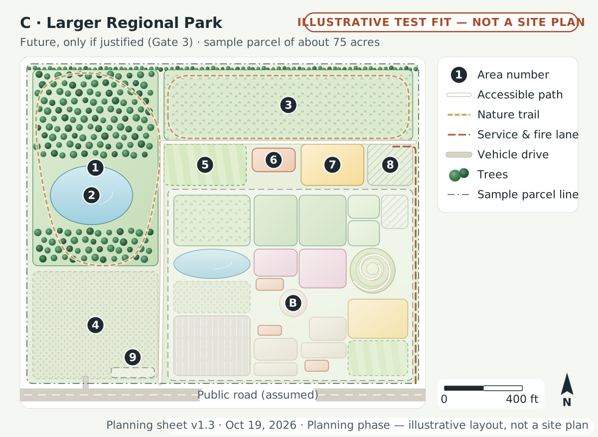 (opens the full-size drawing in a new tab)
Key, legend and notes
Sample parcel 2,000 × 1,630 ft (assumed) = 74.8 acres
Key
- BThe Scale B core: family attraction park, about 28 ac: 27.98 ac · 1,250 × 975 ft
- 1Nature preserve, woods & stream buffer: 14.69 ac · 640 × 1,000 ft
- 2Wetlands & boardwalk loop: 2.27 ac
- 3North meadow & trail network: 10.50 ac · 1,270 × 360 ft
- 4Festival meadow / event overflow parking: 8.01 ac · 640 × 545 ft
- 5Amphitheater lawn & stage: 2.02 ac · 420 × 210 ft
- 6Four-season Discovery Hall, with room for the small ocean corner: 0.61 ac · 220 × 120 ft
- 7Expansion rides area: 1.54 ac · 320 × 210 ft
- 8Operations expansion & storage: 1.11 ac · 230 × 210 ft
- 9Possible Bethlehem Connect stop (separate project; placeholder): 0.25 ac · 220 × 50 ft
Legend
- Area number
- Numbered areas; the key lists each one with its area and dimensions
- Accessible path
- Accessible path, 8–12 ft, target slope 5% or less; about 2,621 ft in this test fit
- Nature trail
- Mown nature trail or boardwalk; about 5,908 ft in this test fit
- Service & fire lane
- Service and fire-apparatus lane, 20 ft minimum; about 1,386 ft in this test fit
- Vehicle drive
- Vehicle drive, 24 ft; about 26 ft in this test fit
- Trees
- Trees and tree belts (placement illustrative)
- Sample parcel line
- Edge of the sample parcel, 2,000 × 1,630 ft (assumed)
Area budget, computed from the drawing
- Phase 1–2 core (Plan B): 28 ac (37%)
- Nature, gardens & water: 25.2 ac (34%)
- Parking & arrival: 8 ac (11%)
- Plazas & gathering: 2 ac (3%)
- Buildings (footprint): 0.6 ac (1%)
- Rides & attractions: 1.5 ac (2%)
- Operations & service: 1.1 ac (1%)
- Future reserve: 0.3 ac (0%)
- Paths, buffers, landscape & stormwater margins: 8.1 ac (11%)
Known (with sources in the brief)
- Bethlehem Connect is a separate project, not an official or funded line; no public program uses that name.
- LANta is cutting service in 2026 and expects more cuts in January 2027, so no new routes are assumed.
- PA ride rules (7 Pa. Code Ch. 139) apply to any expansion ride.
- A full aquarium is not part of this park: it belongs to the separate Ocean Discovery Center project.
Unknown (to verify)
- Whether Gate 3 is met: proven demand, sufficient land, operating surplus, environmental review.
- A site of about 50–120 acres, and the streams, wetlands, woods and habitat on it.
- FEMA flood zones, soils and utility capacity.
- Event traffic and effects on neighbors.
- Capital and operating costs (about $60M–$150M+ is a placeholder, not an estimate).
- Expansion is gated (Gate 3): proven demand, sufficient land, an operating surplus and an environmental review.
- B: the Scale B core (about 28 ac, Phase 2), shown in the southeast at the same scale.
- Nature preserve is sized to protect streams, wetlands and woods first; development fits around them.
- Festival meadow doubles as event overflow parking and stormwater meadow.
- A full aquarium is not shown: it belongs to the separate Ocean Discovery Center project.
- Bethlehem Connect is a separate project; its stop here is a placeholder only, with no route or service assumed.
- Public road (assumed) on the south edge; a secondary access point (not shown) depends on the real site.
- Independent community project, planning phase: nothing is funded or built yet. Not an official municipal project. Dimensions are planning assumptions only; no engineering has been performed.
A nature preserve, only if justified
A Larger Regional Park (Scale C) would happen only if proven demand, sufficient land, an operating surplus and an environmental review all support it. It could sit near the low end of its 50 to 120 acre range if a site already has protected woods or wetlands. In the test fit, the festival meadow also doubles as a stormwater meadow.
What we know and what we do not
Known, with sources
- Bethlehem’s “40 in 10” parks plan, which engaged more than 4,000 people, heard demand for inclusive and natural play.
- The South Bethlehem Greenway’s final phase was fully funded on July 23, 2025.
- The Lehigh River and the Monocacy, Saucon and Bushkill creeks all flood.
- Our research found no aquarium within about an hour of Bethlehem and no active Lehigh Valley aquarium proposal.
- In the test fits, nature, gardens and water fill about 29% of the Scale A parcel and 25% of the Scale B parcel.
Unknown, still to check
- Which site, if any, would host the park, and what wetlands, habitat and protected species it holds.
- Flood zones at any real site.
- Whether construction on the Greenway’s final phase started in 2026.
- Which museums, schools or nature groups might want to help later. None has been contacted.
- The real costs of programs, the Discovery Barn and a small ocean corner.
Help shape it
Do you know the birds, plants or history of a place we should learn from? Tell us what your family would love to explore.
Share an idea